
Today is Saint Patrick’s Day. A feast day celebrated by many Christians to honor Saint Patrick, a patron saint of Ireland.
Beyond its religious significance, Saint Patrick’s Day has long been an American holiday honoring all things Irish. But you need not be Irish to partake in the festivities. You don’t even have to add a “Mc” or “Mac” (“son of”) or an “O” (“grandson of”) to your name.
Some communities celebrate their Irish heritage on this one day by turning their river green (shout out to the people of Chicago) and others expect more than 2 million people to line their streets to watch a massive parade (here’s to you, New York City).
But the Freedom Valley has one community that speaks of Irish heritage all year long.
Connaughtown.
Irish by name. Irish by heritage.
All-American today.
People from a wide variety of ethnic groups reside in Connaghtown. But in its early days, it was the Irish that settled this community.
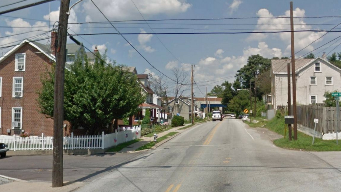
Connaughtown is a small community on the border of Plymouth Township and Conshohocken Borough; the neighborhood includes lands in both municipalities. For those traveling on Conshohocken Road or Elm Street, the community may appear to be just another section of Conshohocken. While sharing the postal district with Conshohocken, Connaughtown is a distinct community unto itself.
The Plymouth Creek provides a distinct boundary between Connaughtown and the rest of Conshohocken. Little development has occurred between the rest of Conshohocken and Connaughtown.
The community was named after the historical Province of Connaught of Ireland; the province is also known as “Connacht”. The other historical provinces of Ireland are Leinster, Ulster, and Munster. (Please note: Even though Herman Munster was a delightful shade of green, it is uncertain if Mr. Munster was Irish by birth – er, by creation.)
Many Irish-Americans trace their linage to Connaught. Several counties in the province were among the areas of Ireland most affected by the Famine. The population of Connaught was decimated by the Famine. Many of those who could leave, left; many came to the United States. Others died of starvation and disease. Most others lived under conditions of oppression. Connaught and much of the rest of Ireland did not become an independent nation in the modern era until 1922.
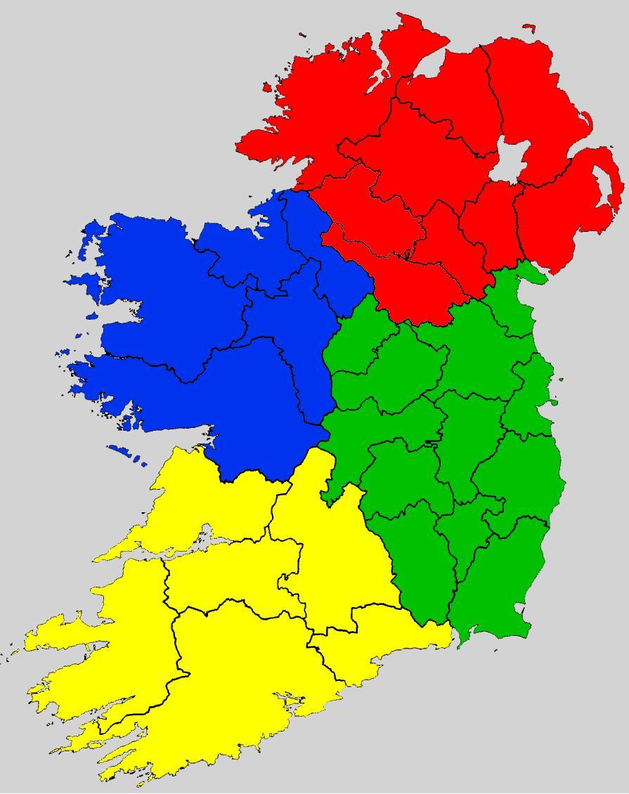
Connaught or Connacht is one of the four historical provinces of Ireland. In this map, Connaught includes the five counties colored in blue.
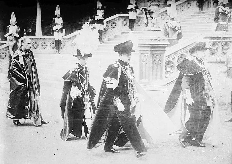
Prince Arthur William Patrick Albert, the Duke of Connaught (also known as the Duke of Connaught and Strathearn), is seen to the right in this photo. The occasion was the investiture of the Prince of Wales, second from the left, into the Order of the Garter on June 10, 1911. Between the two members of royalty of the United Kingdom is King Manuel II of Portugal. (The other individuals in the photo are not identified.)
The event took place at Saint George’s Chapel at Windsor Castle in England. Please note that the Duke was not Irish; he was the son of Queen Victoria and born in England. The Duke of Connaught served as the Governor General of Canada from 1911 to 1916.
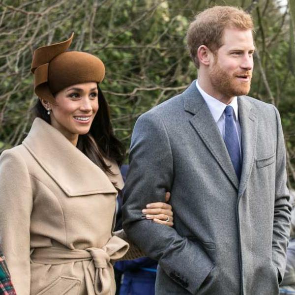
Rachel Meghan Markle, better known as “Meghan Markle”, and Prince Henry Charles Albert David, better known as “Prince Harry”, plan to marry at the same locale as seen in the photograph from 1911. Their wedding is planned to take place at Saint George’s Chapel at Windsor Castle on May 19, 2018.
This is also the same location that Prince Arthur William Patrick Albert, the Duke of Connaught, married Princess Louise Margaret of Prussia on March 13, 1879. (Yes, the same country that is the namesake of King of Prussia, Pennsylvania.)
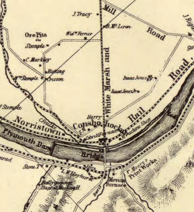
In 1848, there was very little development in Conshohocken or West Conshohocken, neither of which existed as separate municipalities. In the lower left-side of this map, you will see “CFoulke”. The location of the wording on this map represents land owned by Mr. Cadwallader Foulke in today’s Connaughtown. Whitemarsh Township included all of the lands east of the Whitemarsh and Plymouth Turnpike above the Schuylkill; Plymouth Township included all of the lands west of that toll road – today’s Fayette Street – above the Schuylkill. Below the Schuylkill, Upper Merion Township included the lands west of Matsonford Road; Lower Merion Township included all the lands east of Matsonford Road below the Schuylkill.
When this section of the Freedom Valley was first settled by Europeans, this area – like much of the region – was initially farmed. Much of Connaughtown was the Foulke Farm, a farm owned by Mr. Cadwallader Foulke.
According to the Borough of Conshohocken, Mr. Foulke was one of only five homeowners within the Village of Conshohocken in 1833; he lived in the Plymouth Township section of the Village. Mr. Foulke was also one of the four men, according to the Borough of Conshohocken, who helped chose the name for the new municipality incorporated in 1850.
Foulke Farm was eventually subdivided into streets and housing lots in 1866.
Most of the founding families of Conshohocken have streets named after them. Mr. Foulke was no different than, say, Mr. David Harry (Harry Street) or Mr. James Wells (Wells Street). The difference is that “Foulke Street” disappeared as the name for the street extending from the intersection of Elm and Corson Streets into Plymouth Township.
Known today officially as “New Elm Street” in Plymouth Township and officially as “Elm Street” in Conshohocken, the section of the roadway from Corson Street to past Fulton Street was initially known as “Foulke Street”.
In the original plan for Foulke Farm, Foulke Street started from near the intersection of Corson and Elm Streets; Foulke Street went west into Plymouth Township. In 1878, a Pennsylvania Court issued the opening of a new Conshohocken Road; in Connaughtown this road was laid out over Foulke Street to Corson Street. It appears that at that point in time, Foulke Street became known as “New Elm Street”. Over time, Elm Street and Foulke Street became effectively one roadway.
As the community developed, the name “Foulke Street” disappeared from the maps of the community. Deeds, though, still carry the name “Foulke Street”. As recently as 1957, a legal advertisement in The Conshohocken Recorder made reference to “New Elm Street formerly known as Foulke Street”.
The Conshohocken Recorder used the name of “Foulke Street” in news articles from 1888 to 1922, among other time periods. In a news article in 1898, the newspaper uses “Foulke Street” as the name for today’s Elm Street as far east as Maple Street. In 1916, the newspaper reported a family on Foulke Street announcing an engagement of their daughter.
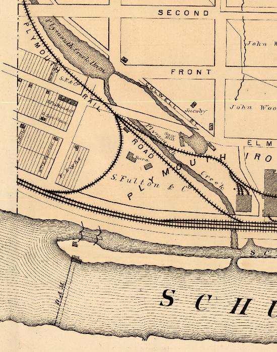
This map, from 1871, shows that Foulke Farm has been subdivided into what became Connaughtown. This map also shows the beginning of how “Elm Street” became “Old Elm Street” and how “Foulke Street” became “New Elm Street”.
Note that Elm Street in Conshohocken ended at what is today Colwell Lane. What was Elm Street in Connaughtown – what is now called “Old Elm Street” – can be seen in the map as the roadway just above the wording “Plymouth” in Plymouth Creek in this map; that street almost connected with the rest of Elm Street in Conshohocken in this map. What was Foulke Street – seen in this map as the street one block below Elm Street in Connaughtown and now known as “New Elm Street” – was not yet connected to Elm Street. Eventually, Foulke Street was connected to Elm Street and became known as “New Elm Street”.
Note that First Avenue used to be known as “Front Avenue”.
Conaughtown is the area is in the center of this map from 1942. The Schuylkill is the wide ribbon from the top left to the bottom right of this image. The Matsonford Bridge can be seen crossing the Schuylkill in the lower right-hand corner of this image. Elm Street connects Downtown Conshohocken with Connaughtown. West Conshohocken is in the lower left-hand corner of the image. The land that appears in lighter shades near the center of the image includes grounds being quarried.
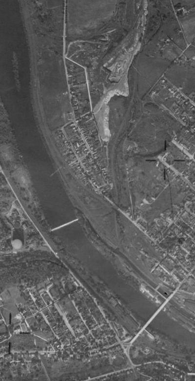
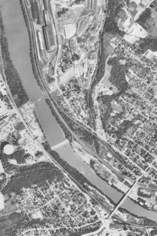
Connaughtown – seen in the middle of this photo – is still a distinct community from the rest of Conshohocken in 1957. The Schuylkill is seen in this aerial photo from the top left to the lower right. The Matsonford Bridge is located in the lower right-hand corner of this image. Industrialization on the lands in Plymouth Township continues.
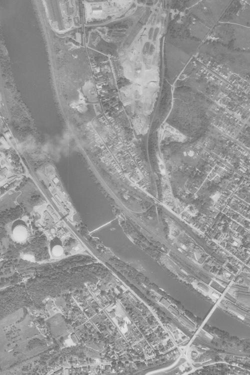
Much of the land in Plymouth Township around Connaughtown has been developed into industrial uses by 1971. The Blue Route has yet to come through the community. The Plymouth Creek continues to provide a distinct boundary between Connaughtown and the rest of Conshohocken.
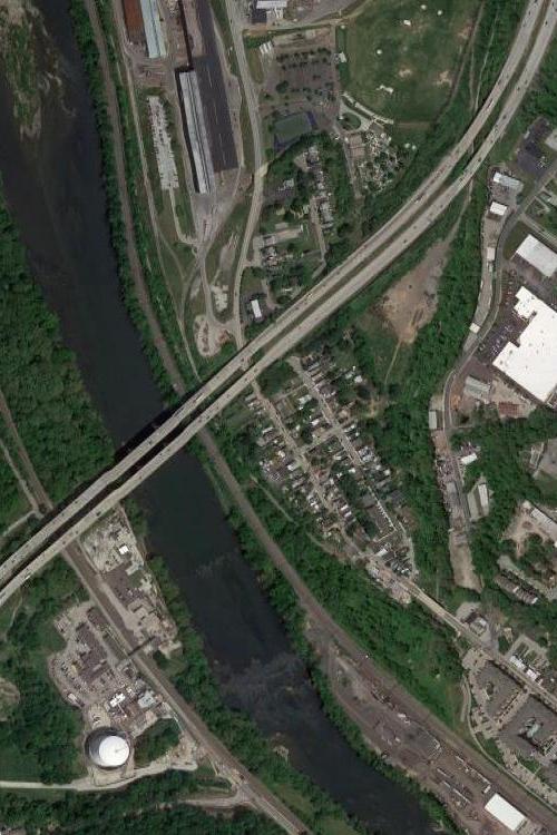
Connaughtown, as it looks today from the air. The Blue Route splits the community. Trees along the Plymouth Creek keep Connaughtown distinct from the rest of Conshohocken.
When the Mid-County Expressway (the “Blue Route”) was built through Montgomery County, Connaughtown was split in two. Literally. Fulton Street was split into two sections divided by the highway. Old Elm Street was also split into two sections by the Blue Route. New Elm Street was retained as a through road connecting Conshohocken Borough and Plymouth Township.
Houses were condemned by the Pennsylvania Department of Transportation and people moved from their homes. A small park of less than an acre, the Alan Wood Park, was spared and remains to this day. The park gets its name from the former Alan Wood Steel Company that donated the land to Plymouth Township on March 22, 1966.
![]()
One of the local institutions that grew out of Connaughtown was the Plymouth Fire Company No. 1. Founded in 1906 by area citizens, this fire company originally housed its equipment at a local business. A firehouse was built on New Elm Street at Light Street in 1908.
For a number of years, the Plymouth Fire Company leased the second floor of its fire station to the Plymouth Township School District; the school district operated the Connaughtown School at that site. According to The Conshohocken Recorder, the fire company sent a letter to the school board on April 30, 1914, informing the school district that it was giving notice to terminate the lease for the school. The fire company indicated that it wanted to proceed with improvements at its fire station and that it would work with the school district in regards to moving the school to another location without hurting the students or causing unnecessary expense to the Township.
According to the Plymouth Fire Company, “One of the early methods adopted to aid in financing the fire company operations was the holding of weekly dances on the second floor of the fire house. John O’Brian, Morris O’Brian, Peter O’Brian, Harry J. Barrett and Mary O’Neill were the members of the poplar local orchestra.”
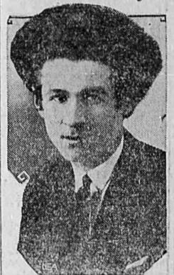
Mr. Eddie Rabbitts, pictured above, was the leader of the orchestra in Connaughtown, according to a news article in The News-Review of Roseburg, Oregon, on July 18, 1927. The newspaper indicated that locals called him “Eddie Hare” because Mr. Rabbitts had 53 curls of hair in his permanent wave hair style.
The Plymouth Fire Company No. 1 moved to a new firehouse in 1978; the fire company now serves Plymouth Township and nearby communities from a firehouse on Colwell Lane.
News about Connaughtown has generally been sparse through years. People generally lived their lives. Went to work. Shopped for food. Loved their children. Just the normal aspects of life.
On a few occasions, when news coverage has appeared, the coverage would focus on the sensational. A few examples follow.
“Boy Attacked by a Dog – The Animal Tossed the Youngster About as Though He Was a Rat” was a headline that appeared in The Philadelphia Times on June 10, 1897. The news article detailed that a 12 year-old boy was nearly killed by a mastiff in Connaughtown. According to the newspaper, “The dog pounced on him with the fury of a wild beast.”
On July 18, 1897, The Daily Telegraph of Harrisburg reported that a resident of Centralia, Pennsylvania, was arrested for fortune telling in Connaughtown. According to the newspaper, the individual arrested was quoted as stating that “It is not I who should be arrested, but the persons who were foolish enough to invest in my predictions.”
The Philadelphia Inquirer reported on November 27, 1904, that “Connaughtown’s Live Bird Match Was Warmly Received”. The newspaper reported that two participants killed all of their live birds “hard”.
On March 3, 1915, the Times-Leader of Wilkes-Barre reported that a grocer in Conshohocken turned a “Black Hand Threat” letter that he had received to local postal officials. The grocer was instructed through the letter to deposit $500.00 in Connaughtown. The grocer and his family were threatened if the funds were not paid.
The Muncie Evening Press of Indiana reported on July 18, 1932, that 50 years earlier – in 1882 – a novel game of baseball was played in Connaughtown. Two rival clubs in the community competed on the ball field. “A keg of beer was placed on third base, and a rule prescribed that no player could have a drink until he reached that station. Every player reached third base, and so frequently that two kegs were emptied before the game was half over.”
A total of 131 men were arrested at the Yo-Eddie Club in Connaughtown on April 30, 1935, according to the Pottstown Mercury. The charges? Frequenting a gambling house. According to the newspaper, 18 of those arrested were held on bail for operating the club, 75 men paid fines, two men were taken to Montgomery Hospital in Norristown, and the rest of those arrested were committed to the local county jail. The Pottstown Mercury reported that most of those arrested were residents of Philadelphia. The two that went to the hospital were among four men that had attempted to elude the state police by jumping out of a second story window – a second story window that overlooked a 200-foot deep quarry, according to the Allentown Morning Call in a news article dated May 1, 1935. The men evidently went down about 50 feet into the quarry. Two of the four were injured (the ones that went to Montgomery Hospital), one was captured, and the fourth man escaped.
Top photo is courtesy of Google, 2017.
The photo of the Duke of Connaught is courtesy of the Library of Congress, 1911. The photograph was published in The New York Times on June 11, 2011.
The photo of Prince Harry and Meghan Markle is courtesy of Mark Jones through Wikipedia, 2017.
The images displayed of 1848 and 1871 maps are portions of maps courtesy of the Commonwealth of Pennsylvania Historical and Museum Commission, 1848 and 1871.
Three aerial photos are courtesy of the United States Department of Agriculture and the Pennsylvania Geological Survey, 1942, 1957, and 1971, while the fourth aerial photo is courtesy of Google, 2018.
The image of patch of the Plymouth Fire Company No. 1 is courtesy of the fire company, 1906.
The image of Eddie Rabbitts is courtesy of The News-Review of Roseburg, Oregon, 1927.
Do you have questions about local history? A street name? A building?
Your questions may be used in a future news article.
Contact Richard McDonough at freedomvalleychronicles@gmail.com.
© 2018 Richard McDonough