
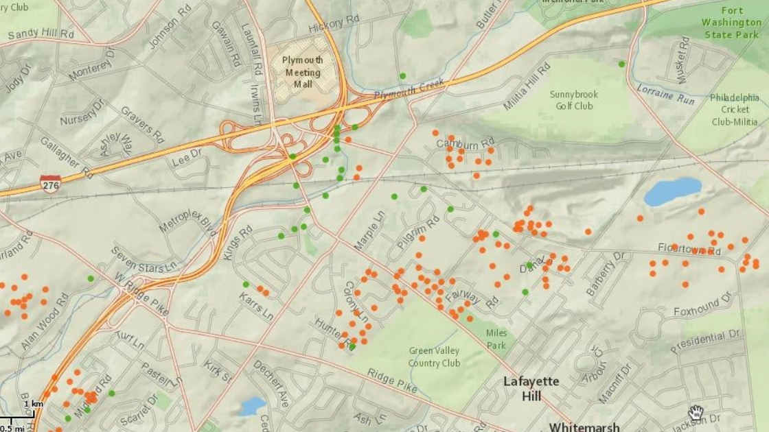
Plymouth Township and Whitemarsh Township are two of the municipalities where sinkholes are part of the landscape. The map above from the Pennsylvania Department of Conservation and Natural Resources shows the location of sinkholes (marked by green dots) known officially to the Commonwealth of Pennsylvania. The map also shows the areas of surface depressions (marked by orange dots) that have been officially identified by the Commonwealth.
Note that a number of the green dots – sinkholes – are in residential neighborhoods that have been built through the years in both of these municipalities. Among the neighborhoods with known sinkholes are Plymouth Meeting Park, Whitemarsh Meadows, Joshua Knoll, Wainwright At Whitemarsh, Whitemarsh Green, Sandwood Village, Woodside Estates, and Farmview Village. Surface depressions have been officially identified in numerous locations, including on properties owned by the Colonial School District and Plymouth and Whitemarsh Townships. Among those properties are the campus of Plymouth Whitemarsh High School, Colwell Park, and Miles Park.
“Typically, sinkholes form so slowly that little change is noticeable, but they can form suddenly when a collapse occurs,” according to the United States Geological Survey (USGS) of the Department of the Interior. “Such a collapse can have a dramatic effect if it occurs in an urban setting.”
“Sinkholes are common where the rock below the land surface is limestone, carbonate rock, salt beds, or rocks that can naturally be dissolved by groundwater circulating through them,” the USGS stated. “As the rock dissolves, spaces and caverns develop underground. Sinkholes are dramatic because the land usually stays intact for a while until the underground spaces just get too big. If there is not enough support for the land above the spaces then a sudden collapse of the land surface can occur.”
The USGS noted that sinkholes can be human-induced: “New sinkholes have been correlated to land-use practices, especially from groundwater pumping and from construction and development practices. Sinkholes can also form when natural water-drainage patterns are changed and new water-diversion systems are developed. Some sinkholes form when the land surface is changed, such as when industrial and runoff-storage ponds are created. The substantial weight of the new material can trigger an underground collapse of supporting material, thus causing a sinkhole.”
 According to the Pennsylvania Department of Conservation and Natural Resources, there are sinkholes and surface depressions in several areas within the Plymouth Meeting Park neighborhood. Sinkholes are noted as green dots on this map. Surface depressions are noted as orange dots on this map.
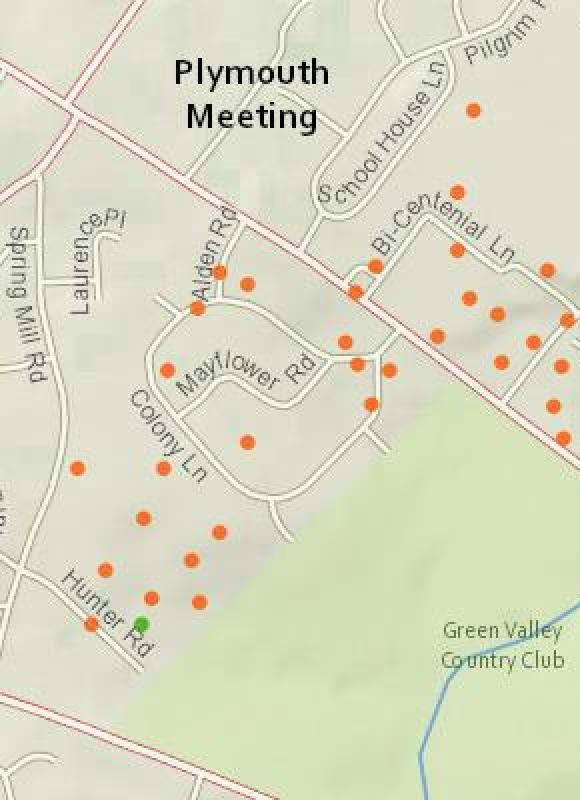 While only one sinkhole (noted by a green dot) has been officially identified by the Pennsylvania Department of Conservation and Natural Resources near Hunter Road, there are numerous surface depressions (noted by orange dots) officially identified throughout part of the Plymouth Meeting Village neighborhood as well as throughout the campus of the Plymouth Whitemarsh High School.
![]() Surface depressions (marked as orange dots) have been officially identified by the Pennsylvania Department of Conservation and Natural Resources throughout the Joshua Knoll, Whitemarsh Green, and Wainwright At Whitemarsh neighborhoods as well as the Victory Field at Plymouth Whitemarsh High School and Miles Park. Sinkholes (marked as green dots) have been officially identified at two sites within Whitemarsh Meadows, two sites within Joshua Knoll, and one site within Whitemarsh Green.
Surface depressions (marked as orange dots) have been officially identified by the Pennsylvania Department of Conservation and Natural Resources throughout the Joshua Knoll, Whitemarsh Green, and Wainwright At Whitemarsh neighborhoods as well as the Victory Field at Plymouth Whitemarsh High School and Miles Park. Sinkholes (marked as green dots) have been officially identified at two sites within Whitemarsh Meadows, two sites within Joshua Knoll, and one site within Whitemarsh Green.
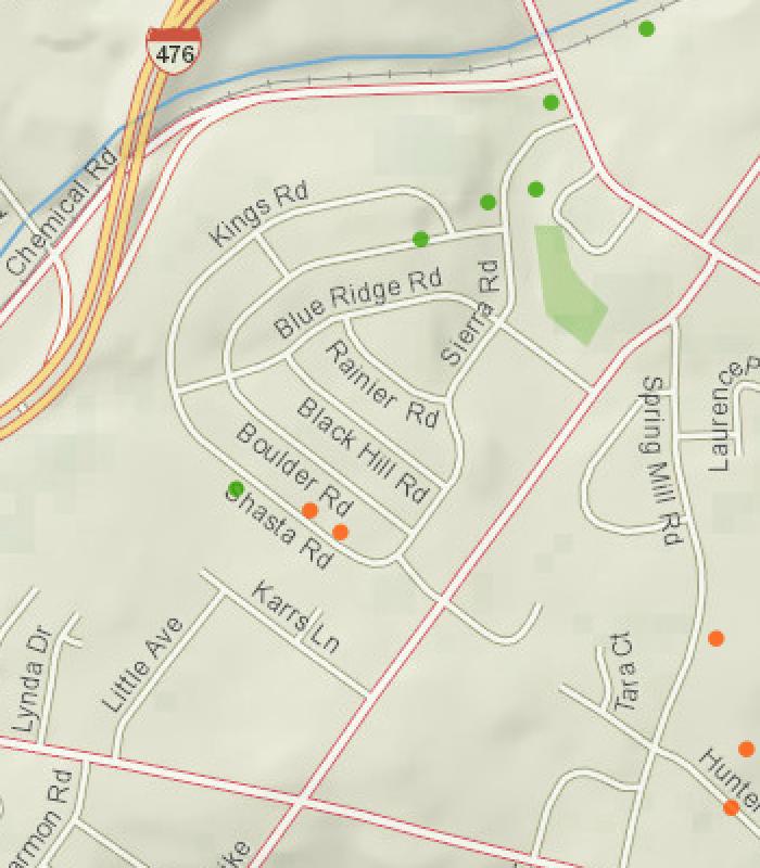
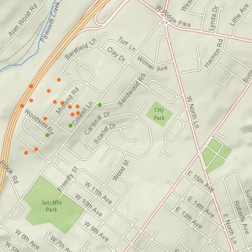 The Farmview Village and Woodside Estates neighborhoods each include one sinkhole (marked as a green dot) officially identified by the Pennsylvania Department of Conservation and Natural Resources as well as a number of surface depressions (noted by orange dots) officially identified by the Department. Sandwood Village includes one sinkhole officially identified by the Department. Surface depressions have also been officially identified at Colwell Park.
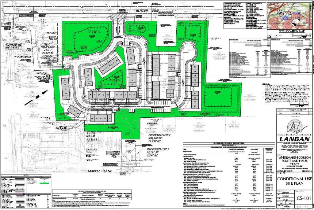 The plans for The Villages At Whitemarsh have identified four sinkholes on the site for the housing development proposed by K. Hovnanian Pennsylvania Acquisitions, LLC. This business is 100% owned by Hovnanian Enterprises, Inc., a New Jersey-based firm active in home building in suburban Philadelphia and in a number of other markets throughout the United States; “K. Hovnanian Homes” is the trade name for Hovnanian Enterprises, Inc.
K. Hovnanian Homes has submitted plans to build townhomes on the land (identified by some as the “Corson and Haub properties”) located along Butler Pike, near Germantown Pike, within Whitemarsh Township.
“During the hearings on our conditional use application before the Whitemarsh Township Board of Supervisors, the Board ruled that issues related to the subsurface geological conditions of the Corson and Haub properties are not relevant to the conditional use proceedings,” noted a statement from K. Hovnanian Homes. “As the conditional use application is still pending before the Board, it would be premature to comment on the presence or absence of sinkholes on the Corson and Haub properties at this time. However, we have investigated the subsurface conditions of the properties and we will address those conditions as required by the Township Ordinances if we receive conditional use approval and proceed forward with a subdivision and land development application.”
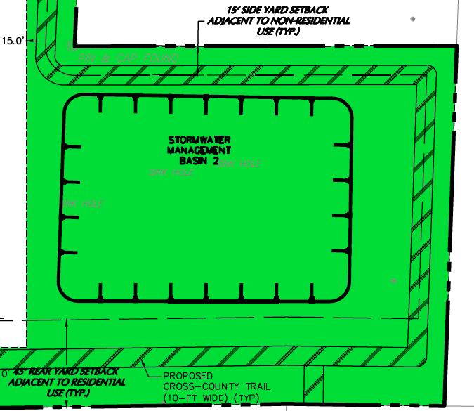 The development plans for The Villages At Whitemarsh call for three identified sinkholes to be incorporated into a stormwater management basin. A fourth sinkhole is also noted on the development plans; that sinkhole is located between this stormwater management basin and Butler Pike.
The Friends of Abolition Hall has opposed the plans presented to Whitemarsh Township for the development The Villages At Whitemarsh, according to Ms. Sydelle Zove, convener of this group of interested individuals.
According to Ms. Zove, “…it [the plan] imperils a delineated wetland and exacerbates flooding and storm water damage on adjacent parcels. It might even imperil the lives and investment of future townhouse owners who discover that the sinkholes upon which their homes were constructed are devouring their properties.” Ms. Zove also stated that “The site plan also shows a roadway, cul-de-sac, and townhouses in areas with known sinkholes, as well as significant ponding.”
The maps are courtesy of the Pennsylvania Department of Conversation and Natural Resources, 2018.
The images of the plan for the proposed development of The Villages At Whitemarsh are courtesy of K. Hovnanian Homes, 2017.
Do you have questions about local history? A street name? A building?
Your questions may be used in a future news column.
Contact Richard McDonough at freedomvalleychronicles@gmail.com.
© 2018 Richard McDonough