
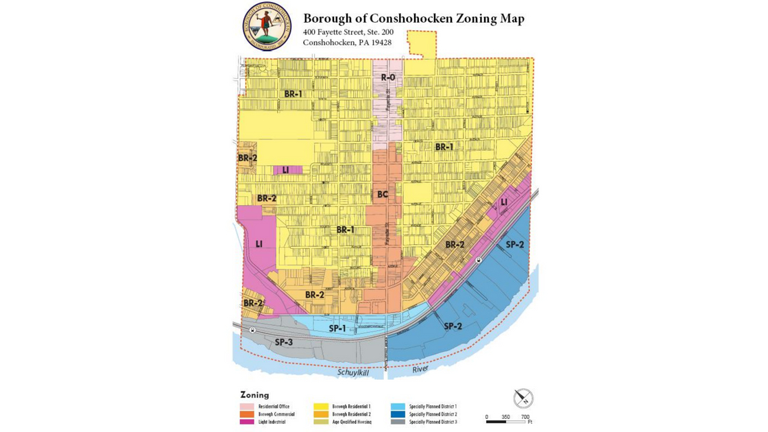
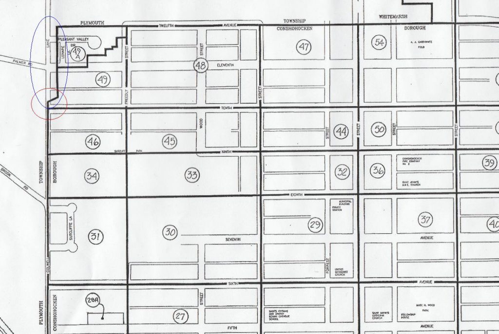
The official map used by the Borough of Conshohocken may be incorrect.
This map, displayed at the top of this news column, includes two elements that may not be accurate.
The first element is located near Colwell Lane and 11th Avenue, along the border between Plymouth Township and Conshohocken Borough. This area includes a number of properties on Colwell Lane, 11th Avenue, Lenape Lane, and Pleasant Valley Drive.
The second element is located along Righter Street and a matching straight line to the Schuylkill, along the border between Whitemarsh Township and Conshohocken Borough. This area includes several properties on Righter Street and other nearby streets.
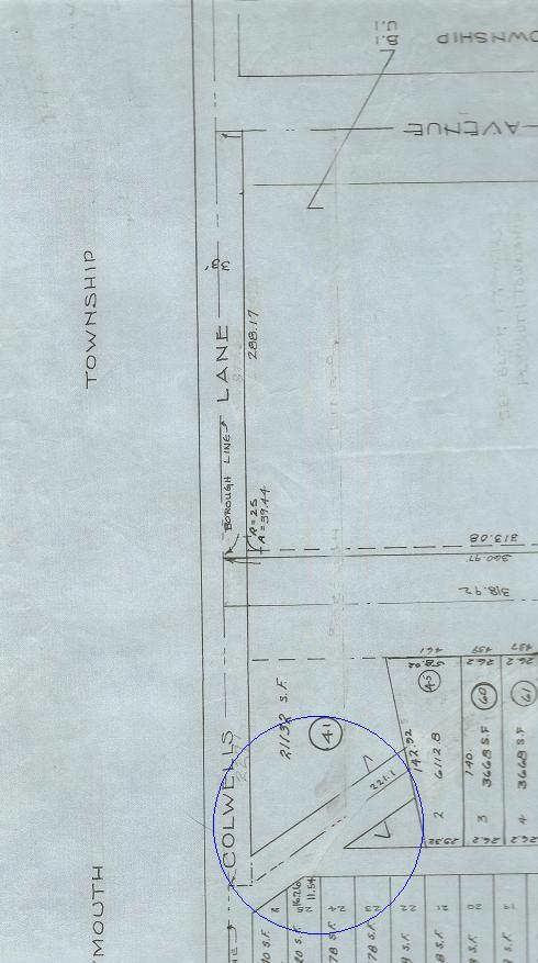
In the upper left-side of the map at the top of this news column, note the notch – an indentation in the two straight lines.
With one exception, the northeast border of Conshohocken is the centerline of 12th Avenue or the 12th Avenue alignment. (Due to development patterns and the geography of the land, 12th Avenue was not built out completely.)
This border applies – with the one exception – to the boundary between the Borough and both Plymouth Township and Whitemarsh Township. The one exception is the “B” Field, also known as the “John Borusiewicz Memorial Field”. This recreational facility has been owned by the Borough for decades even though the land was for much of its history officially part of Whitemarsh Township. In 1968, this parcel of land officially became part of the Borough of Conshohocken.
According to records, the northwest boundary of Conshohocken is the centerline of Colwell Lane from the curve of that roadway – from south of 5th Avenue – to the 12th Avenue alignment.
The official map of Montgomery County follows these boundaries.
The official map of Plymouth Township follows these boundaries.
The official map of the Borough of Conshohocken follows these boundaries for much of its borders with Plymouth Township, but it does not follow those borders in this Notch.
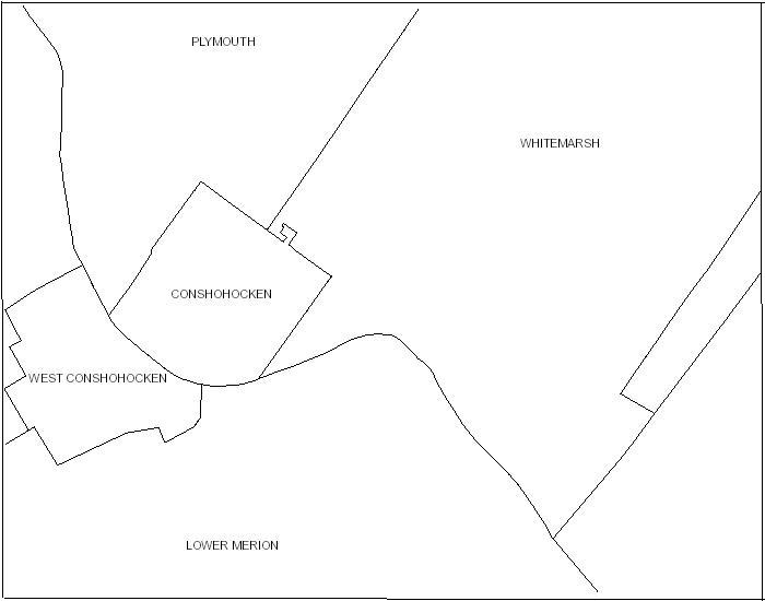
This map from Montgomery County shows that the boundary lines are, for the most part, straight lines for the Borough of Conshohocken between this municipality and Plymouth Township and Whitemarsh Township. There is no Notch of Conshohocken in the official municipality map of Montgomery County.
The exception to the straight lines with Whitemarsh Township is the B Field, also known as the “John Borusiewicz Memorial Field”. This park is almost completely surrounded by Whitemarsh Township. The exception with Plymouth Township is part of a curve in Colwell Lane.
Please note that the Schuylkill is the large curve in the border that Conshohocken shares with the Borough of West Conshohocken and Lower Merion Township.
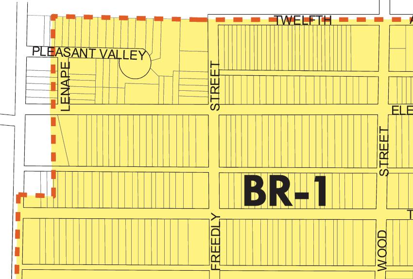
This is a detailed piece of the map at the top of this news column. Note the notch along Colwell Lane, from just above 10th Avenue to the 12th Avenue alignment. Certain portions of the properties in this notch area may not have zoning, at least according to the official map of the Borough of Conshohocken. Plymouth Township does not include the properties in the Notch of Conshohocken in its boundaries.
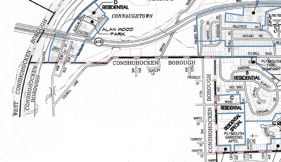
This map is part of the zoning map of Plymouth Township as of 2015. Note that the official border between Conshohocken Borough and Plymouth Township is along Colwell Lane, between the curve in Colwell Lane to the 12th Avenue alignment. There is no Notch of Conshohocken in the official map of Plymouth Township.
The second element is located on the right side of the map at the top of this news column – the map that is the official map of the Borough of Conshohocken.
This map shows part of the boundary between Whitemarsh Township and Conshohocken Borough to be east of Righter Street, between 9th and 12th Avenues. The Borough map also shows that the border with Whitemarsh Township continues on a matching straight line from 9th Avenue to the Schuylkill.
According to other records, this section of the border between the two municipalities is Righter Street from 9th to 12th Avenues and a matching straight line from 9th Avenue to the Schuylkill.
The official map of Montgomery County follows these boundaries.
The official map of Whitemarsh Township follows these boundaries.
The official map of the Borough of Conshohocken does not follow these boundaries for this portion of its border with Whitemarsh Township.
The two maps displayed below show that certain portions of the properties east of Righter Street and the matching straight line to the Schuylkill may have two types of zoning – one type of zoning prescribed by Whitemarsh Township and a second type of zoning prescribed by Conshohocken Borough.
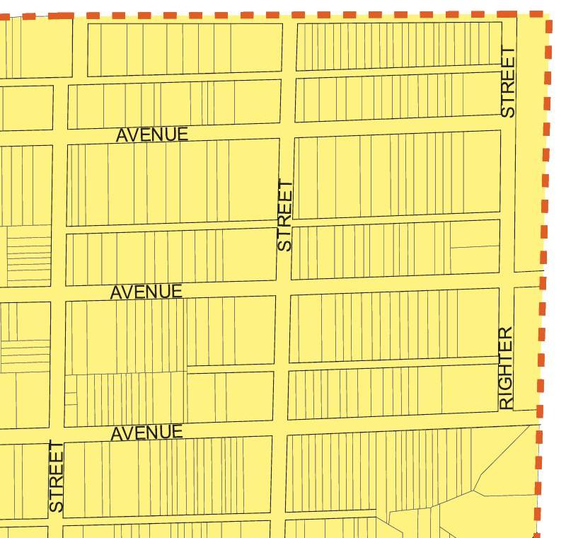
This is another detailed piece of the map at the top of this news column. Note the official map of the Borough of Conshohocken shows that the boundary with Whitemarsh Township to be east of Righter Street between 9th and 12th Avenues and east of a matching straight line between 9th Avenue and the Schuylkill.
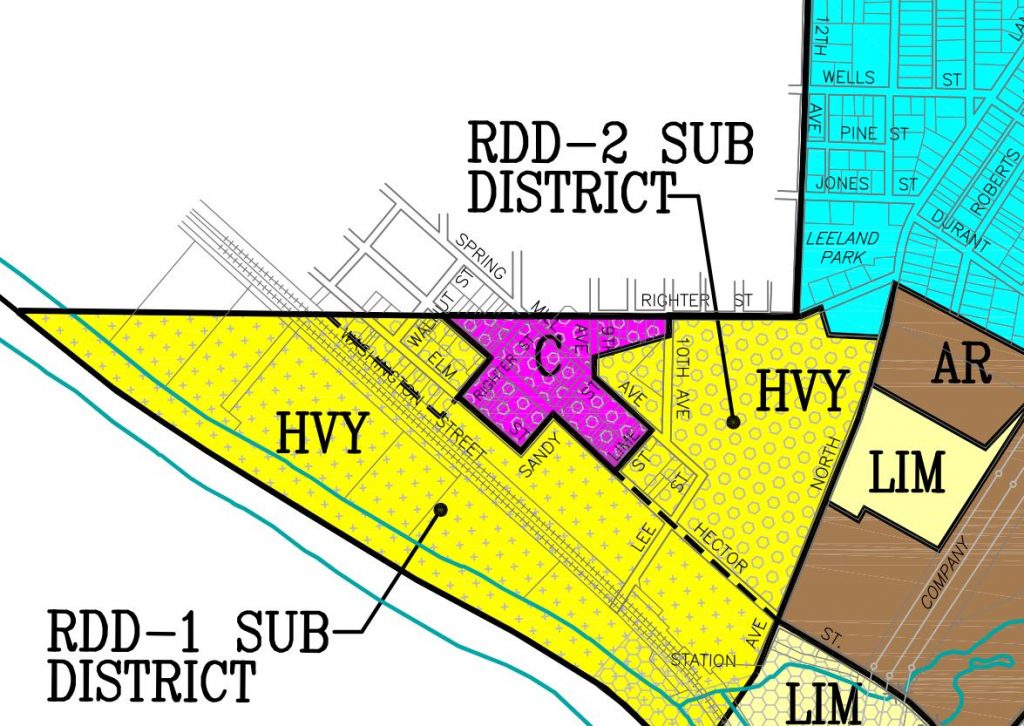
This map is part of the zoning map of Whitemarsh Township. Note that the official border between Conshohocken Borough and Whitemarsh Township is along Righter Street, between 9th Avenue and 12th Avenue, and along a matching straight line between 9th Avenue and the Schuylkill.
Both Whitemarsh Township and Montgomery County have the lands east of Righter Street – and east of a matching straight line between 9th Avenue and the Schuylkill – within the boundaries of Whitemarsh Township.
According to the official map of the Borough of Conshohocken, these homes on the odd-numbered side of Righter Street are partially within the borders of the Borough. Yet, both Whitemarsh Township and Montgomery County indicate that all of these specific parcels of property are solely within Whitemarsh Township. Property owners pay municipal real estate property taxes only to Whitemarsh Township, not to the Borough of Conshohocken.
It is likely that the boundaries between the Borough of Conshohocken are the borders recognized by Montgomery County, Plymouth Township, and Whitemarsh Township – not the borders reflected in the official map of the Borough of Conshohocken.
The reasons for this likelihood are as follows:
The Conshohocken Recorder reported in a news article dated November 5, 1926, that “the court confirmed the annexation yesterday [November 4, 1926]” by the Borough of Conshohocken of a strip of land from “a point approximately 47 feet from the south side” of the 5th Avenue alignment up to 12th Avenue “extending to the center of Colwell’s road.”
Mr. Dominic Coccia, Jr., the Tax Collector of the Borough of Conshohocken for real estate property taxes, was able to confirm that all property owners in the Notch of Conshohocken pay municipal real estate property taxes to the Borough of Conshohocken. Property owners in the Notch do not pay municipal real estate property taxes to Plymouth Township.
The tax records of Montgomery County detail that owners of property located east of Righter Street, between 9th and 12th Avenues, are assessed municipal real estate property taxes only by Whitemarsh Township, not by the Borough of Conshohocken.
The Montgomery County Planning Commission was able to confirm that it reviewed the development plans for Pleasant Valley Homes on three occasions. This review included plans to build houses on a section of 11th Avenue as well as on Lenape Lane and Pleasant Valley Drive.
The correspondence from the Montgomery County Planning Commission regarding its decisions were sent only to the Borough of Conshohocken. Had the property in question been located in two municipalities – say Conshohocken and Plymouth – the records of the Montgomery County Planning Commission would show that review letters were sent to both municipalities.
For example, the Montgomery County Planning Commission received a request from the Borough of Conshohocken to review a development plan for Pleasant Valley Homes in a letter dated March 23, 1990. The Commission sent its recommendations back to the Borough in a letter dated April 16, 1990.
In this specific area of the Notch of Conshohocken, only the Borough was contacted by the Montgomery County Planning Commission regarding the plans for Pleasant Valley Homes. Not Plymouth Township.
According to the official map of the Borough of Conshohocken, portions of these properties along Colwell Lane and Lenape Lane in Pleasant Valley Homes are in Plymouth Township.
Montgomery County records show that all of the housing lots for this residential development are within the borders of the Borough of Conshohocken. That includes all of the housing lots located along Colwell Lane, 11th Avenue, Lenape Lane, and Pleasant Valley Drive within the plans for Pleasant Valley Homes.
While the official map of the Borough indicates several of these housing lots are partially located in Plymouth Township, the Borough alone approved this housing development. Plymouth Township had no official role in the approval of Pleasant Valley Homes.
How did these discrepancies come about?
No one, thus far, knows for sure. It is extremely likely that no one will ever actually know how the discrepancies occurred.
But there are indications that the problem with the Notch of Conshohocken may have been in place for, potentially, more than 90 years.
In 1926, area maps may not have been updated when Plymouth Township allowed the Borough of Conshohocken to annex a strip of land along the existing boundary between the two municipalities. The new boundary was set along Colwell Lane, from the curve in Colwell Lane below 5th Avenue to 12th Avenue. Plans at that time called for all the avenues above 5th Avenue to be built out to Colwell Lane.
For decades, there was a roadway named “Whiskey Lane” that went from Colwell Lane to Butler Pike; this was a diagonal road not in keeping with the straight lines of the avenues in the Plan for Borough of Conshohocken.
It may be possible that when Montgomery County and/or the Borough of Conshohocken updated their maps after the annexation of 1926 that one or both of these governmental entities stopped the expansion of the Borough at Whiskey Lane rather than 12th Avenue.
Montgomery County still shows the Notch of Conshohocken on the town-wide map that displays the individual block map borders for the Borough of Conshohocken. The line that appears to be sideways is where Whiskey Lane used to exist. The actual block maps that include the area in the Notch of Conshohocken show the official borders between Plymouth Township and Conshohocken Borough to be along Colwell Lane and the 12th Avenue alignment in this area.
This map is a portion of a larger map utilized by Montgomery County as the overall block (or plate) map for the Borough of Conshohocken. A roadway named “Whiskey Lane” used to exist along the sideway line detailed in the red circle. Much of the area in the blue circle represents the Notch of Conshohocken, located above the former Whiskey Lane. The actual maps for Block 49 and Block 49A show the boundary between Conshohocken Borough and Plymouth Township to be Colwell Lane and the 12th Avenue alignment.
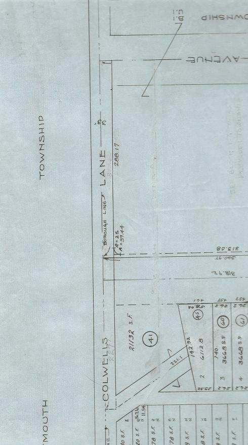
This map is a portion of the actual block map used by Montgomery County for Block 49 of the Borough of Conshohocken. Though it displays as light in color – because it was erased – there is the remnant of a line east of Colwell Lane that was listed as the border between Conshohocken Borough and Plymouth Township. That erased line went from 12th Avenue alignment to Whiskey Lane. The specific date when the Notch of Conshohocken was removed from the Montgomery County maps is uncertain; it could have been possibly decades ago. Today, when an official map is altered, Montgomery County notes the date of that map change. Several maps below highlight specific details of this portion of the block map for Block 49.
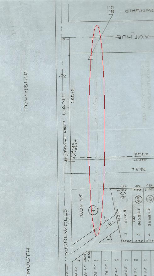
The former border between Plymouth Township and Conshohocken Borough is highlighted in a red circle in this portion of the map for Block 49 – the official map used by Montgomery County to detail the parcels of land in this section of the Borough of Conshohocken. The border between the two municipalities was moved with the consent of Plymouth Township to Colwell Lane by court order in 1926.
For some reason, this section of the previous border between the two municipalities remained on the official map of Montgomery County. At some point – perhaps decades ago – this previous border was erased from the map for Block 49. The wording above the remnant of that previous border line states “Borough Line” in faint markings that were not erased completely.
Portions of the previous border line between Conshohocken Borough and Plymouth Township remain in use to this day – in the overall town-wide block map still used by Montgomery County and in the official map for the Borough of Conshohocken.
Thus, the Notch of Conshohocken.
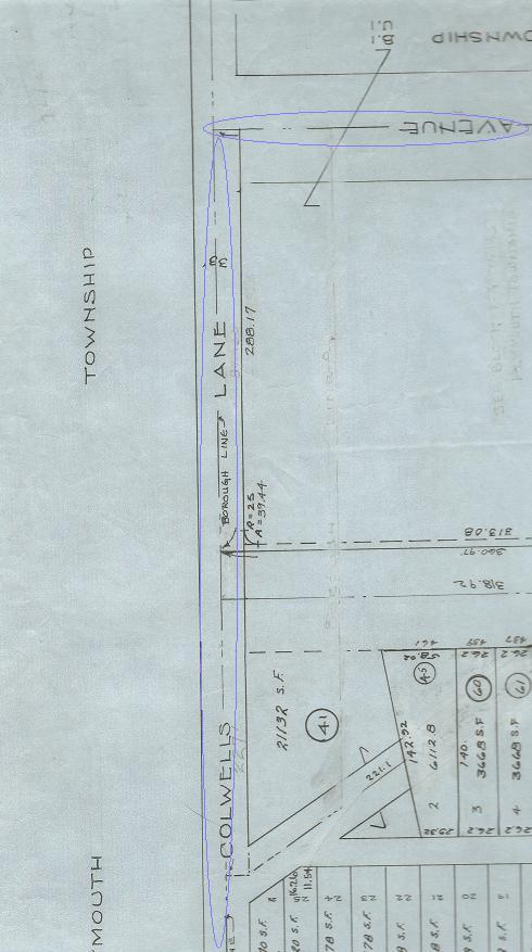
This map shows a portion of Block 49 with two areas outlined in blue circles. The lines in these two circles represent what Montgomery County considers to be the official borders between Conshohocken Borough and Plymouth Township in this area – Colwell Lane (displayed as “Colwells Lane”) to the left in this block map and 12th Avenue at the top of this block map.
The alignment for Whiskey Lane – in the blue circle – is still displayed in this portion of the map for Block 49 used as the official map by Montgomery County to detail the parcels of land in this section of the Borough of Conshohocken. The official map for the Borough of Conshohocken includes a similar boundary line that, while not identical, is roughly in the same area as the alignment for Whiskey Lane.
Thus, the Notch of Conshohocken.
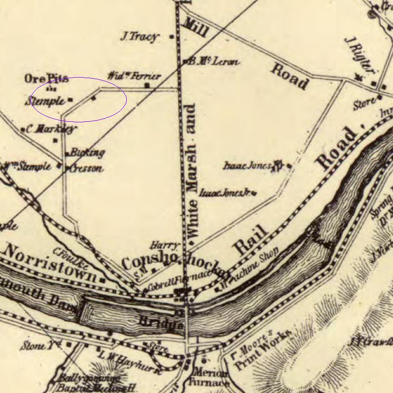
This map from 1848 shows the Conshohocken area before the Borough was incorporated.
A portion of Whiskey Lane is highlighted in the purple circle as the diagonal road from Colwell Lane to Butler Pike. At this time, what is known as “Colwell Lane” today did not go to Ridge Pike.
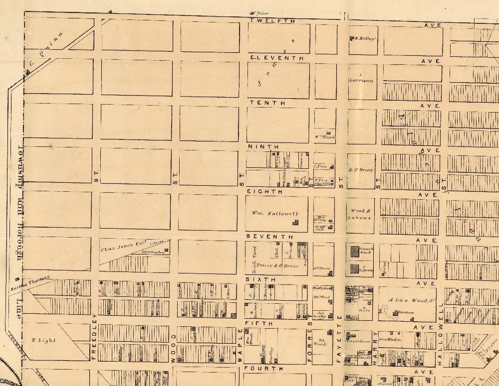
This map from 1871 shows the border between Conshohocken Borough and Plymouth Township to be east of Colwell Lane at that time. Whiskey Lane is the diagonal road from Colwell Lane to 12th Avenue in the upper left-hand side of this map. Please note that this map shows where the Plan for the Borough of Conshohocken anticipated roads would be built. Many of these roadways were not actually built at that time. (Some of the roadways have never actually been built according to the plan.)
Whiskey Lane appears to have played a key role in the creation of the Notch of Conshohocken.
According to the Borough of Conshohocken, two ordinances were passed to lay out Whiskey Lane, while three other ordinances were passed to remove Whiskey Lane from the official map of the Borough.
On January 13, 1955, the municipality passed an ordinance “Laying out, opening and ordaining a public street in the Borough of Conshohocken known as ‘Whiskey Lane.” This pertained to the portion of Whiskey Lane between West Eleventh Avenue and West Twelfth Avenue. The Conshohocken Recorder confirmed this ordinance was enacted in its edition dated January 27, 1955.
On March 14, 1955, Conshohocken passed an ordinance “To vacate and strike from the Borough Plan of the Borough of Conshohocken a street, 33 feet in width, known as ‘Whiskey Lane,’ extending between West Eleventh Avenue and West Twelfth Avenue.” The Conshohocken Recorder confirmed this ordinance was approved by the Borough in the newspaper’s edition dated March 24, 1955.
On February 15, 1958, the Borough passed an ordinance “To vacate and strike from the Borough Plan of the Borough of Conshohocken a street, 33 feet in width, known as ‘Whiskey Lane,’ extending between West Eleventh Avenue and Colwell Road.” The Conshohocken Recorder confirmed this ordinance was passed by the governmental officials in the Borough in an edition of the newspaper dated March 20, 1958.
On June 13, 1958, the municipality passed an ordinance “Laying out, opening and ordaining a public street in the Borough of Conshohocken between Eleventh Avenue and an alleyway running from Colwell Road, known as ‘Whiskey Lane.’”
Also on June 13, 1958, Conshohocken passed an ordinance “To vacate and strike from the Borough Plan of the Borough of Conshohocken a street, 33 feet in width, known as ‘Whiskey Lane,’ extending between West Eleventh Avenue and Colwell Road.”
Beyond the possible involvement of Whiskey Lane, it is also possible that part of the reason for the Notch of Conshohocken is that much of the land in this area was previously part of a larger parcel of ground located in both Plymouth Township and the Borough of Conshohocken. Much of this larger parcel was the site of the Harmonville Impounding Basin that stored silt from the Schuylkill. With common ownership, there may have been no pressing need to delineate the border in this open area. When the land was developed – especially with the development of Pleasant Valley Homes – the correct boundary between the municipalities was critical.
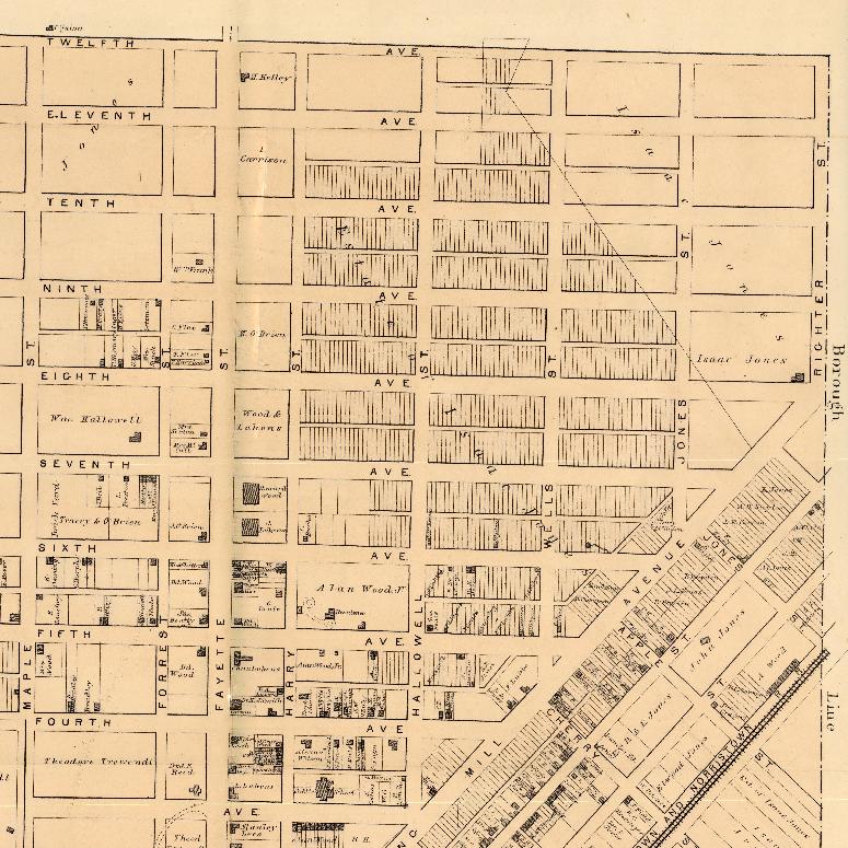
This map of the Plan for the Borough of Conshohocken was produced in 1871. Note that Righter Street and a matching straight line that follows a similar alignment to the Schuylkill is the border between the Borough and Whitemarsh Township. The official map for Conshohocken today has the border east of Righter Street and the matching straight line to the Schuylkill. Please note that this map, like a previous map, shows where the Plan for the Borough of Conshohocken anticipated roads would be built. Many of these roadways were not actually built at that time. (As noted above, some of the roadways have never actually been built according to the plan.)
The discrepancies in the border between the Borough of Conshohocken and Plymouth Township may mean that portions of certain properties in the Notch of Conshohocken have no zoning and, thus, the owners of the properties in the Notch area may only have to follow zoning regulations on portions of their properties.
The discrepancies in the border between the Borough of Conshohocken and Whitemarsh Township may mean that portions of certain properties along Righter Street between 9th and 12th Avenues and the matching straight line from 9th Avenue to the Schuylkill may be in two different zoning districts at the same exact time and, thus, the owners of the properties in this area may be unable to follow either municipal zoning correctly.
The Borough of Conshohocken is reviewing this situation.
The top image is the official Zoning Map of the Borough of Conshohocken and is courtesy of that municipality, 2018.
The second map is a portion of the official municipal border map of Montgomery County and is courtesy of that governmental entity, 2018.
The third and fifth maps are portions of the official Zoning Map of the Borough of Conshohocken and are courtesy of that municipality, 2018.
The fourth map is a portion of the official Zoning Map of Plymouth Township and is courtesy of that municipality, 2015.
The sixth map is a portion of the Zoning Map of Whitemarsh Township and is courtesy of that municipality, 2018.
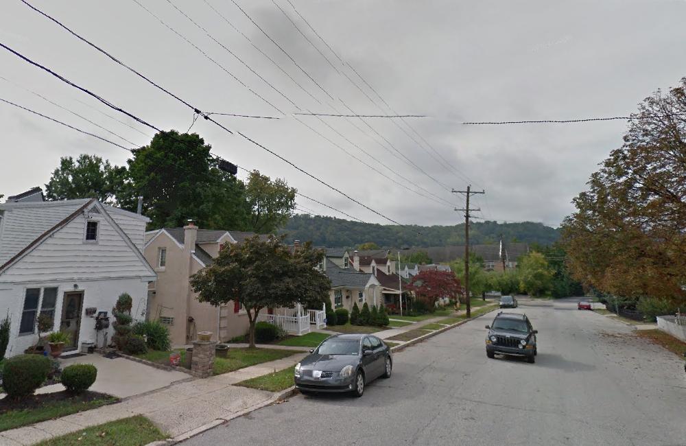
The seventh image is a photograph of Righter Street and is courtesy of Google, 2014.
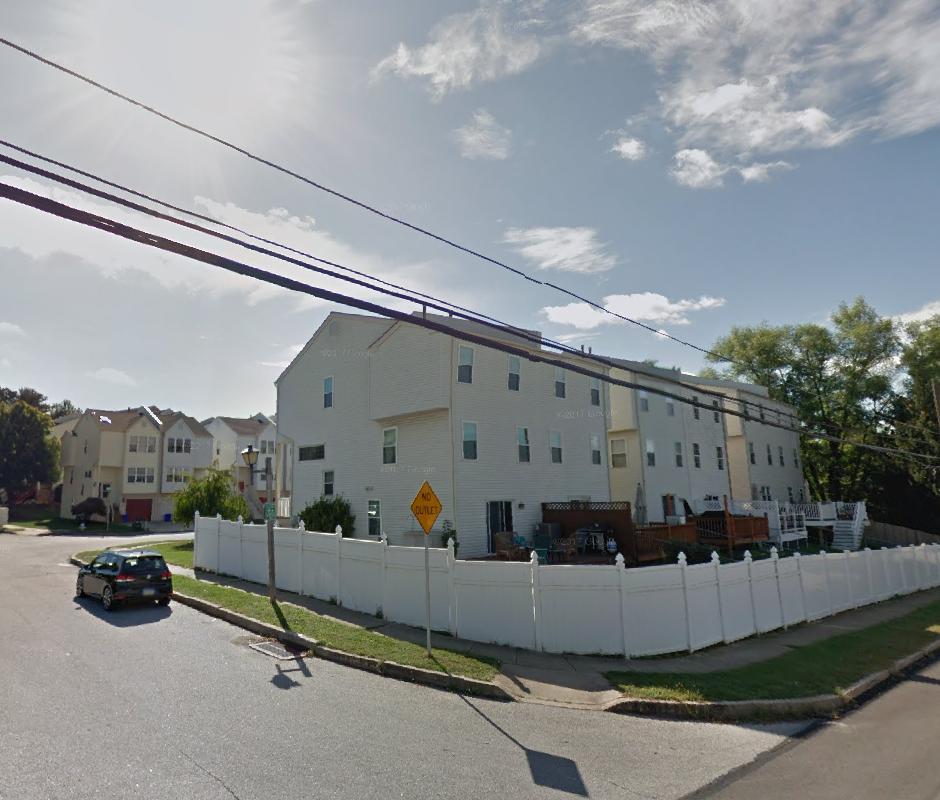
The eighth image is a photograph of the Pleasant Valley Homes and is courtesy of Google, 2017.
The ninth, tenth, eleventh, twelfth, and thirteenth maps are courtesy of Montgomery County, 2018.
The fourteenth map is a portion of a map from 1848 and is courtesy of the Commonwealth of Pennsylvania Historical and Museum Commission.
The fifteenth and sixteenth maps are portions of a map from 1871 and are courtesy of the Commonwealth of Pennsylvania Historical and Museum Commission.
Do you have questions about local history? A street name? A building?
Your questions may be used in a future news article.
Contact Richard McDonough at freedomvalleychronicles@gmail.com.
© 2018 Richard McDonough