
For a little bit more than a year, More Than The Curve has hosted The Freedom Valley Chronicles.
The concept was to provide detailed news columns that highlight the history and its impact on the Boroughs of Conshohocken and West Conshohocken, Plymouth and Whitemarsh Townships, and nearby communities that share the postal districts within these four municipalities in the Freedom Valley.
More Than The Curve was willing to include The Freedom Valley Chronicles, believing that this type of civic journalism would help put into context how the area developed as well as provide information that would help people make decisions regarding current events.
The subjects of the news columns have ranged from where streets got their names to how neighborhoods were developed.
The Freedom Valley Chronicles detailed how “obvious” things aren’t always correct. For example, Franklin, Harry, Hector, and Joshua are all first names, but locally, only “Joshua Road” is named after a man with the first name of “Joshua” – Joshua Paxton. The other three roadways were named after specific people with surnames of Franklin, Harry, and Hector – Benjamin Franklin, David Harry, and Edward Hector.
The type of civic journalism utilized through The Freedom Valley Chronicles includes going to original sources, where available, to determine facts. While most news articles will provide “both sides” of an issue, this type of civic journalism strives to include “all sides” of an issue. That may mean 17 different sides to an issue, rather than just two sides.
Civic journalism lets the story take the lead, rather than finding “facts” to fit the lead.
This approach may verify long-held beliefs or it may question facts considered long-settled.
A few examples:
The individual that likely flipped the light switch that caused the spark that destroyed about one-third of the Plymouth Meeting Mall was identified through The Freedom Valley Chronicles. Details about the first 23 minutes of the massive fire in 1970 were detailed publicly for the first time. The assistance provided by Norristown, Whitemarsh, Whitpain, and other locales to help the people of Plymouth fight this fire. Because of the Plymouth Meeting Mall fire, building codes were updated for shopping malls throughout the United States.
The House of Representatives of the United States updated the official biography of Congresswoman Millicent Fenwick after The Freedom Valley Chronicles found that the date of her marriage was off by two years. While the efforts by this individual to champion human rights were well-known by many, almost no one knew that this woman was beaten by two thugs in the City of New York for speaking against Nazism in the Summer of 1941. Think about it: A 31-year-old woman assaulted in the City of New York because she stood for the civil rights of people.
The Freedom Valley Chronicles found that the Commonwealth had the date incorrect for the installation of a historical marker to honor the efforts of Edward Hector. The records, which had had the incorrect date of dedication for more than forty years, were then corrected by the Pennsylvania Historical and Museum Commission.
The Pennsylvania Department of Transportation updated its official map of the Borough of Conshohocken after news reporting by The Freedom Valley Chronicles. Land that had been annexed by the Borough in 1968 had “officially” remained within Whitemarsh Township until September of this year.
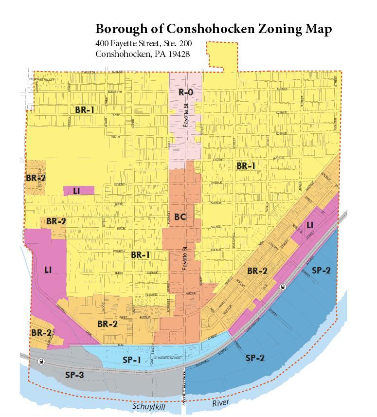
The Freedom Valley Chronicles detailed that the zoning map used – to this day – by the Borough of Conshohocken does not include land that is recognized by every other affected governmental entity as being in the Borough, while at the same time includes land that is officially recognized by every other governmental entity as being in Whitemarsh Township. The ward map utilized by the Borough also does not include certain properties that have paid taxes to the Borough of Conshohocken for decades.
Is it possible that the governments of Plymouth Township, Whitemarsh Township, Montgomery County, and the Commonwealth are all wrong regarding the borders of the Borough of Conshohocken?
Yes, of course, it is possible. Likely, though, no.
If the other governmental entities are incorrect regarding the borders of the Borough of Conshohocken, then the Borough of Conshohocken has been receiving tax monies for decades from people who should be paying taxes to Plymouth Township, and the Borough of Conshohocken has not been receiving proper payment of taxes from people who have instead been paying taxes to Whitemarsh Township.
The Borough of Conshohocken has continued its silence in responding to requests for information and for comments from The Freedom Valley Chronicles. With one exception – which was a “we’re reviewing this situation” regarding the zoning map – the government of the Borough of Conshohocken has declined to respond with answers to any of the telephone calls and emails from The Freedom Valley Chronicles.
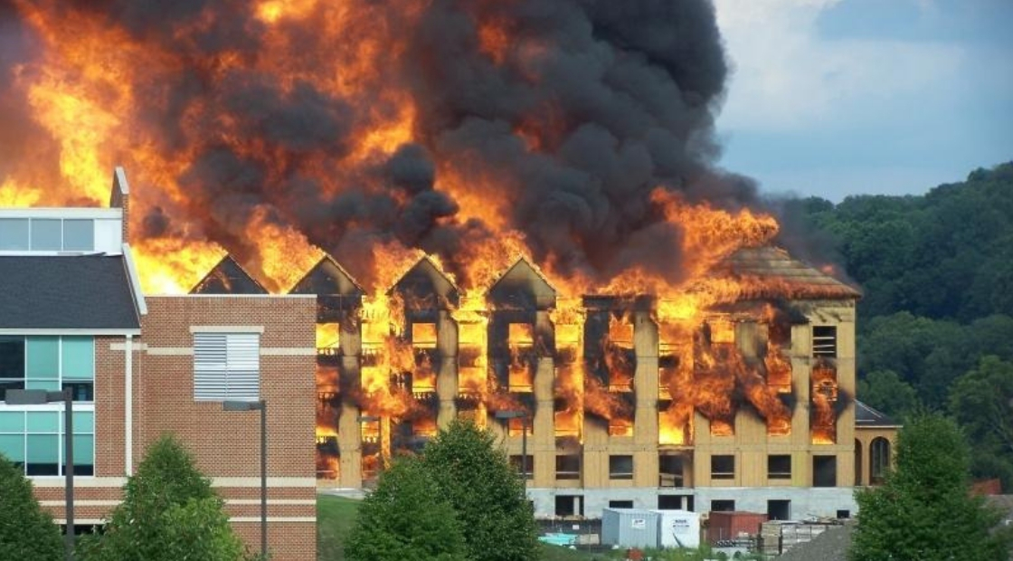
Even with the news columns that detailed the Millennium Fire in Conshohocken, the Borough government has remained silent. These news columns detailed the massive fire that devastated a section of Conshohocken ten years ago. The top photograph shows this inferno. Approximately 375 people became homeless in a matter of hours. Amazingly, no human beings died during this inferno. More than 1,000 firefighters and other first responders from throughout the region – from Berks County to Delaware County, from Upper Gwynedd to Exeter – helped protect the people and property of Conshohocken.
Yet, no comment from current officials of the Borough of Conshohocken regarding building codes, fire codes, waterline pressure, and related matters.
This silence does not stop the news columns, but it does present questions for the Borough government.
Sometimes, the information detailed in The Freedom Valley Chronicles confirms what people “know”, but sometimes, the information calls into question public statements. For example, the proposed housing development of land at Germantown Pike and Butler Pike in Whitemarsh Township has focused on historical buildings as well as sinkholes on the property, among other issues.
The Freedom Valley Chronicles detailed that Abolition Hall, one of the most historic buildings in the area, is likely not the same building as the Abolition Hall that was established when a carriage house was expanded in 1856. The news column quoted news articles from several newspapers – including The New York Times and The Reading Times – that the structure that was the original Abolition Hall likely burned down in a fire in 1901.
What is called “Abolition Hall” today is likely a structure re-built on the foundation of the original Abolition Hall. This possibility does not necessarily diminish the importance of Abolition Hall, but it is important for people to realize that history does not stand still.
The White House, for example, was set on fire by the British in 1814. The structure was re-built shortly afterward and has been subsequently re-built/renovated several times. Those facts don’t diminish the historical significance of The White House.
In public discussions about the proposed development of the Plymouth Meeting property at Germantown and Butler Pikes, several people noted an oral tradition that runaway slaves hid in cornfields on the property in the mid-1800s. The Freedom Valley Chronicles detailed that it was highly unlikely that there were corn fields on the property in the mid-1800s, and even more unlikely that runaway slaves would be outside in view of people during that time period. The risks to those fleeing human bondage and to those striving to protect them were substantial. The compassion and kindness of those risking their lives to protect Americans of African descent would likely have led to the runaway slaves being treated as the human beings they were by having them stay and dine with family members in the buildings – not keeping them in cornfields.
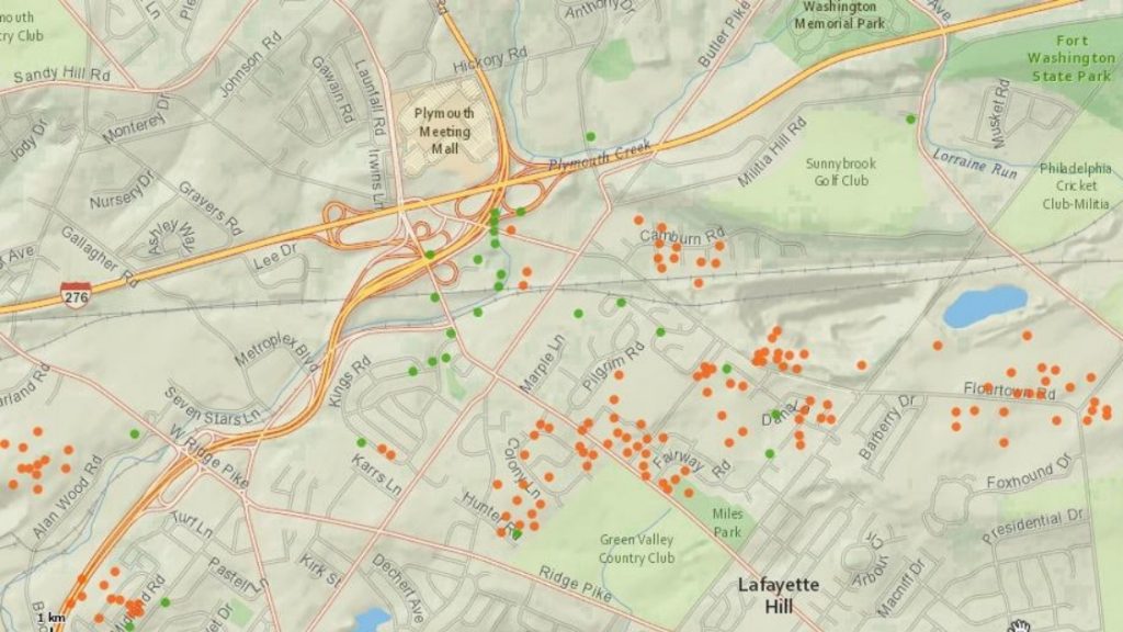
Sinkholes are – and have been – part of the landscape of the Freedom Valley for centuries. The green dots indicate sinkholes that have been mapped, while the orange dots signify surface depressions.
The Freedom Valley Chronicles detailed the sinkholes on this property in Whitemarsh Township as well as throughout the region. Some readers were shocked to realize that millions of dollars have been spent in this region to deal with the impact of sinkholes on infrastructure, including roadways and bridges. The news columns noted a number of surface depressions on school and park properties in the area. A number of residential neighborhoods found that they too had sinkholes and surface depressions within their boundaries.
A news column that was to focus on how a small church in West Conshohocken was being redeveloped into condominiums developed instead into a series of news columns by The Freedom Valley Chronicles that highlighted the heroic efforts of a young man on the battlefield in Italy during World War II, the aid provided to the American soldier by two German Nazi soldiers, his return home grievously wounded, the love between him and his bride-to-be that was used as a role model for others throughout the nation, and the love that the Conshohockens showed this family through the years.
Another series of news columns by The Freedom Valley Chronicles detailed the heroic efforts of firefighters to save West Conshohocken and its people in 1971. A massive gas explosion damaged and destroyed a number of buildings, killed 5 people, and injured dozens. One of those killed and most of those injured were firefighters striving to contain fires and explosions.
Not all of the news columns have focused on slavery, sinkholes, fires, and war.
Many of the news columns have highlighted other topics of interest.
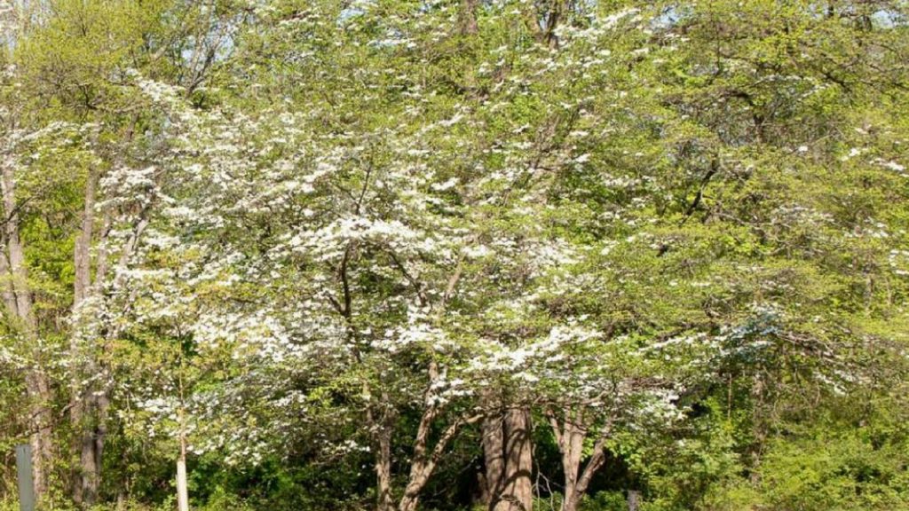
The beauty of the Dogwoods blooming in Fort Washington in the Spring. Streets named after geological features of national importance – Yellowstone, Blue Ridge, and Boulder. An airport that used to operate on Ridge Pike. The varieties of Maple trees in Conshohocken and the Commonwealth. The children parading through Highfield Farms on the Fourth of July. Young people racing in the Soap Box Derby on Fayette Street.
There are many more stories to be explored. To be told.
The top photograph is provided courtesy of Ms. Ying Nichada, August 13, 2008.
The image of the zoning map of the Borough of Conshohocken is provided courtesy of the Borough of Conshohocken, 2018.
The map of the sinkhole and surface depressions is provided courtesy of the Pennsylvania Department of Conversation and Natural Resources, 2018.
The photograph of the Dogwood trees is provided courtesy of the Fort Washington State Park, 2018.
Do you have questions about local history? A street name? A building?
Your questions may be used in a future news column.
Contact Richard McDonough at freedomvalleychronicles@gmail.com.
© 2018 Richard McDonough