
As MoreThanTheCurve.com has extensively reported, the Borough of Conshohocken’s ward map has been illegal for decades. Essentially, the boundaries of the wards weren’t adjusted as the population density changed. The law requires municipalities to review this issue after every census. This hasn’t been done.
In 2025, the borough council established a task force to recommend how to address this issue. During an April 1st meeting of the council, the task force made a presentation and presented three maps that met the requirements as outlined by state law and the borough.
You can watch the presentation below (it is cued to the start of the presentation). The article continues below video.
The three proposed maps were created by Stacy Elam, who represents ward six on borough council, Marlowe Doman, a member of the zoning hearing board, and Kathleen Kingsley, who represents ward 5 on borough council. They were all members of the task force. One map was submitted by a resident, but it did not fall within the legal requirements.
State law requires that the wards have populations that are within 10% of each other. There are also underlying boundaries called census blocks that can not be broken up (for this proposed ward change). The task force also had to base the maps on the numbers from the 2020 Census and could not take into consideration where there will be likely population growth in future (remember, this is supposed to be done every decade, so we are just four years away from the next census). The borough council required the task force to maintain seven wards.
The big issue was how to handle the density of population created by the apartments and condominiums that line the riverfront and West Elm Street. They also tried to maintain Fayette Street as a natural split between the wards on the east and the west sides of town.
Below we are going to offer some commentary on the maps. Before we get the specifics generally we want to offer that requiring seven wards and not supporting having any at-large members of council was a missed opportunity.
Requiring seven wards resulted in less options on how to divide the borough. While we understand that there are issues separating the apartments (for example, Matson Mill and The Birch are in the same census block), the requirement for seven wards didn’t allow for a full exploration of other possibilities.
The three proposed maps have created a scenario where candidates to represent ward one can’t campaign door-to-door unless an apartment complex owner or HOA allows them access. It also is creating a ward that is dominated by the population that is the least politically engaged at the borough level. This isn’t a knock on people in the apartment buildings (the average apartment lease is two years), but it is the reality.
Seven wards for a one square mile community is also an issue when it comes to candidate quality. Imagine having two great potential candidates who are neighbors and both want to run for council. If they are both in the same political party, they would need to run against each other in a primary. If they were in different parties, they would meet in a general election. In the end, only one could serve. If there were at least some at-large seats, there would be a path for both to serve (one could run to represent a ward, the other for an at-large seat).
The majority party in Conshohocken, the Democratic Party, isn’t keen on primaries and even it has trouble finding solid candidates every election cycle due to the ward system. The local Republicans often don’t field a full slate of candidates. Finding quality candidates, who want to run, within such small areas, is not providing for the opportunity for elections to produce the best representation on council. This can be improved by creating a mix of ward-based and at-large seats on council. Or, just go all at-large (this is done in West Conshohocken and a some other boroughs across the state).
Now to the current map and the proposed maps. These are what they are, so we are just pointing out the differences.
The Current Ward Map
Larger Map

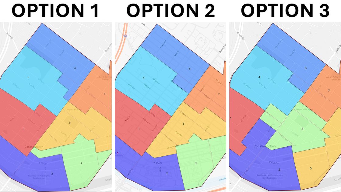
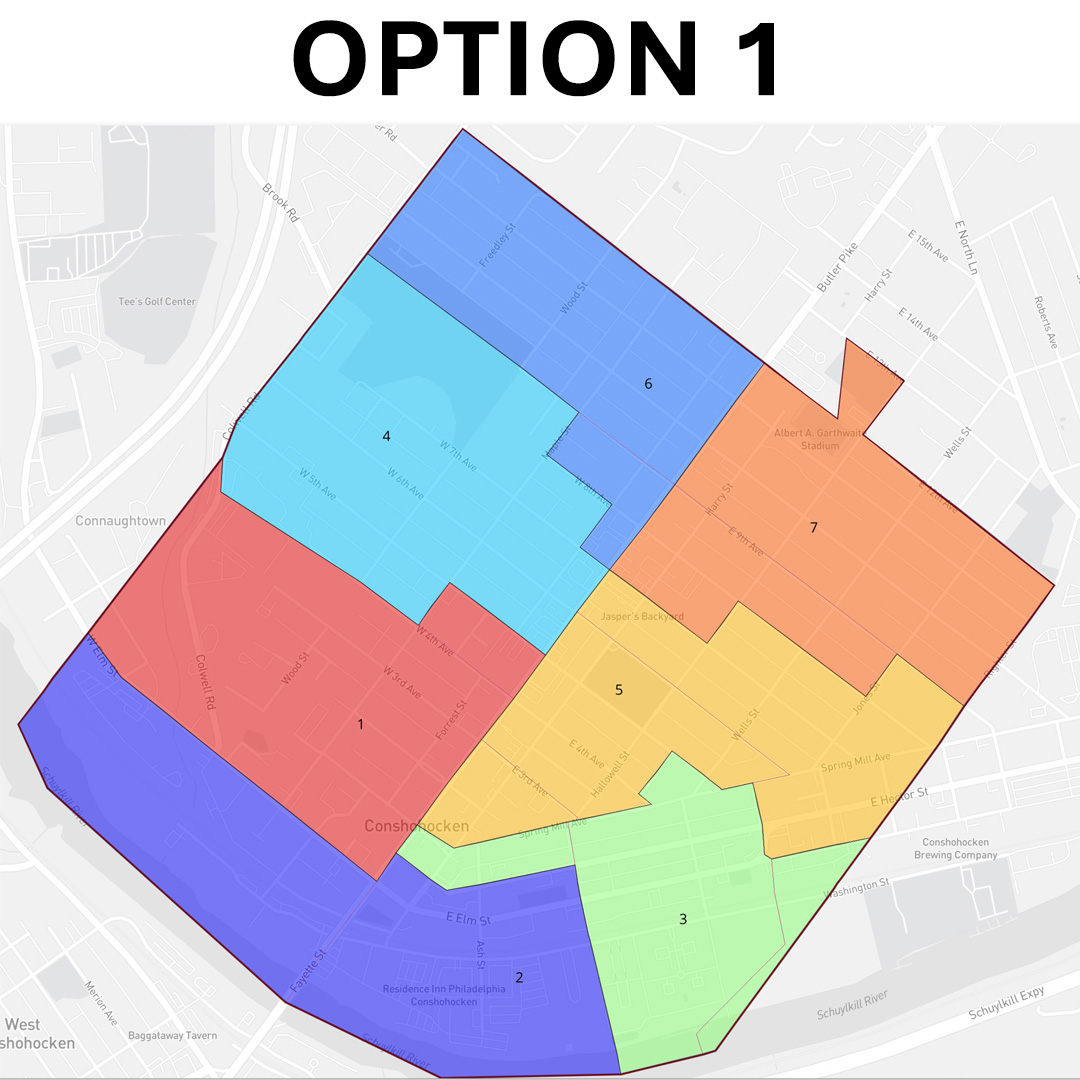
Option 1 was submitted by Stacy Elam. This option proposes Ward 2 as essentially all apartments and condos. The branch created to touch Fayette Street make it look like it was something unnecessarily desired vs. a natural configuration.
Larger Map
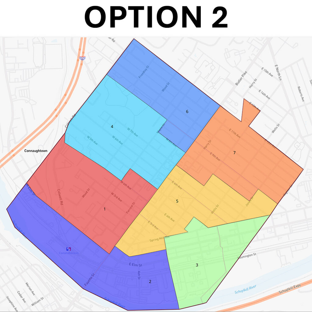
Option 2 by Marlowe Doman is very similar to the first option, but doesn’t create that branch to Fayette Street. It keeps the east side wards more tightly defined. Doman’s third ward does not touch Fayette Street.
Larger Map
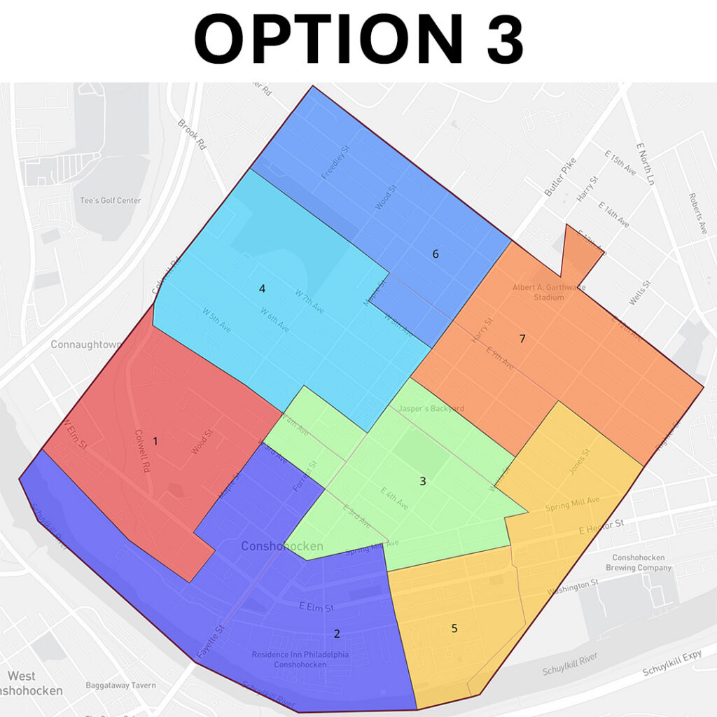
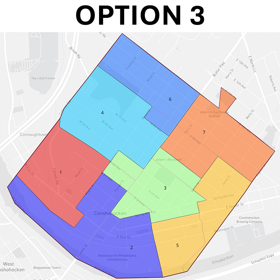
Option 3 from Kathleen Kingsley made the most effort to breakup the apartments and condos. Her map has The Grand and Madison West Elm in the first ward, while Matson Mill and The Birch are in the second ward. Kingsley has the third ward (which looks like Texas) crossing Fayette Street and the fifth ward not touching Fayette.
Wards 1, 2, and 5 would all have two large apartment/condo complexes within them.
Larger Map
This process involves several stages and level of approval. At this stage, the borough council is soliciting feedback from residents. Any input must be received by April 13th at noon via email to Borough Manager Stephanie Cecco at scecco@conshohockenpa.gov or call 610-828-1092 and ask for Stephanie Cecco or Brittany Rogers to submit your feedback.
Please note that they are soliciting feedback on the three proposed maps (but don’t be afraid to tell them the concerns we raised).
Images – Borough of Conshohocken