
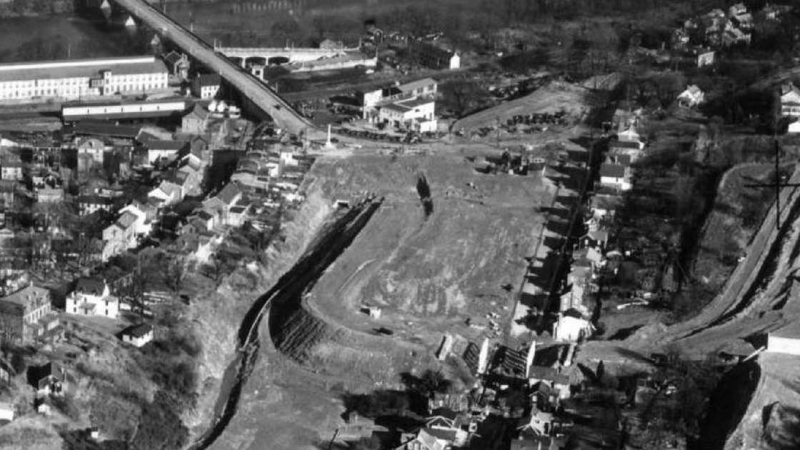
The above photograph shows West Conshohocken during the time when the Schuylkill Expressway was being built through the town in early 1952. The opening of the expressway to Gulph Mills was still about 11 months in the future, while the opening of the expressway to Philadelphia was still years in the future.
During the time of construction for the expressway, land was scrapped bare – homes destroyed, trees uprooted, life as the people knew it had changed. According to the West Conshohocken Centennial Celebration Program Booklet, 20 homes were destroyed just within the Borough to clear the way for the highway.
Progress was coming to West Conshohocken in the form of a modern, four-lane, limited access expressway.
It was originally envisioned as a parkway – the Valley Forge Parkway. Linking the Valley Forge State Park (yep, it was a state park long before becoming a national park – the Commonwealth donated the state park as a Bicentennial gift to the federal government on July 4, 1976) to Fairmount Park in Philadelphia.
Leaders envisioned people taking leisurely trips from park to park – from Valley Forge to Center City Philadelphia.
Eventually, the planners decided that an expressway would help speed commerce into the City of Philadelphia.
Almost from its opening, though, traffic on the Schuylkill Expressway exceeded its design standards. No question that the new highway was better than the local roads, but the Schuylkill was not quite a “parkway” or an “expressway”.
Imagine being a trucker transporting products into Philadelphia in the 1950’s. How did you travel to the City? Well, before the Schuylkill Expressway was built all the way into the City, the Commonwealth asked truckers to use Montgomery Avenue from Gulph Mills – through Lower Merion – to get to Philadelphia.
The top photograph gives a perspective of the town in the early 1950’s.
In the upper left side of this photo is the Matsonford Bridge. A car can be seen heading across the bridge to Conshohocken.
A white building can be seen in the upper middle part of the top photograph. Today, this is the site of the Marriott Hotel.
Many of the houses that can be seen in this photo are ones that can still be seen today as you travel along streets in West Conshohocken. For example, many of the houses in the middle of the photo on the right side can also still be seen today along Moorehead Avenue.
Where’s the McDonald’s?
Not yet built.
The restaurant came years later. At the time of this photo, the site of McDonald’s of West Conshohocken – almost in the middle of the photo – was nothing more than dirt.
McDonald’s had one location – in southern California – at the time of this photo.
Matsonford Road would eventually be built from the lower left of this photo to where the bridge is location. You can see culverts being built in the middle of the photograph.
Workplaces have changed over the years, but many people still work in buildings in West Conshohocken. For example, people worked in the large white building that can be seen in the upper left side of the photograph. Today, this same location is the site of Five Tower Bridge. One Tower Bridge is located today on the site of the buildings between that large white building in the photo and Front Street.
The opening of the Schuylkill Expressway to Gulph Mills in 1952 was but a precursor to the changes that came to both Conshohockens as the Schuylkill Expressway was extended into the City of Philadelphia and as the Mid-County Expressway – the Blue Route – connected the community with northeastern Pennsylvania as well as with Chester and Interstate 95.
Top Photo – The photo displayed here is a portion of the original photo that appeared in the Philadelphia Evening Bulletin on January 3, 1952. (Photo is courtesy of the George D. McDowell Philadelphia Evening Bulletin Photographic Collection of Temple University.)
How has your life been affected by the Schuylkill Expressway?
Let us know. Your comments may be used in a future news article.
Do you have questions about local history? A street name? A building?
Your questions may be used in a future news article.
Contact Richard McDonough at freedomvalleychronicles@gmail.com.
© Richard McDonough