
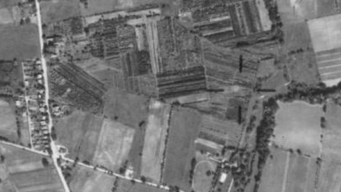
The “A Tree Growing In Plymouth” display at the Plymouth Meeting Mall highlights a specific tree that had been planted in Plymouth Township in 1770. This specific tree was one of the trees growing in this photo taken on October 8, 1942. The tree would have been 172 years old at the time of this photo.
As was the case in much of the Freedom Valley, Plymouth Township was substantially rural in flavor in this section of the municipality in 1942. Notice the rows of dark objects in this photo. Those dark objects are trees. Land was farmed in a number of properties near the crossroads of Germantown Pike – seen from the top left-side of this photo to the bottom of the photo – and Plymouth Road – seen from the left-side of the photo to the bottom near the right-side. The other roadway seen near the top of the photo is Hickory Road. Note that Hickory Road curved as it approached Germantown Pike. Today, much of the land in this photograph is the site of the Plymouth Meeting Mall.
For many years, much of this area was known as “Hickorytown” rather than “Plymouth Meeting”. Plymouth Meeting, for much of its history, was chiefly the area within less than a mile or so of the intersection of Butler and Germantown Pikes. The name “Hickorytown” came from the hickory trees in the area. The Hickorytown Post Office was established here in 1857. In 1871, a map of Plymouth Township shows the Hickorytown Post Office located in a store on Germantown Pike on the grounds of what is now the Plymouth Meeting Mall.

You can still see dense growth of trees – in the middle of this photograph – in 1958. At the time of this photo, much of this property was Meehan’s Nursery. Today, this land is the site of the Plymouth Meeting Mall. The tree displayed in the “A Tree Growing In Plymouth” was 188 years old at the time of this aerial photo taken on September 23, 1958.
To put this photo in perspective, Germantown Pike is the roadway that is on the left-side of the photo – from the top to the bottom. The Norristown Interchange of the Pennsylvania Turnpike on Germantown Pike can be see at the bottom left of this photo. The main East-West portion of the Pennsylvania Turnpike can be seen from the lower left-side of this photo to the middle of the right-side of the photograph. The Northeast Extension of the Pennsylvania Turnpike starts with its Interchange – near the middle on the right-side of this photo – on the main East-West portion of the Turnpike and is seen going towards northeastern Pennsylvania at the top of the photo. Plymouth Road runs from the lower left-side of the photo to near the bottom on the right-side of the photo. Hickory Road can barely be seen near the top of the photo.
Note that the opening of the Pennsylvania Turnpike – both its main East-West portion in 1954 and its Northeast Extension in 1955 – brought toll roads back to Plymouth Township. Travelers on the Germantown Turnpike – today’s Germantown Pike – had to pay tolls to travel along this highway that operated within the City of Philadelphia and into the Freedom Valley for much of the 19th century. In a map from 1871, a toll gate existed on the Germantown Turnpike at Plymouth Road. That location is within a short distance of toll gates maintained today by the Pennsylvania Turnpike Commission.
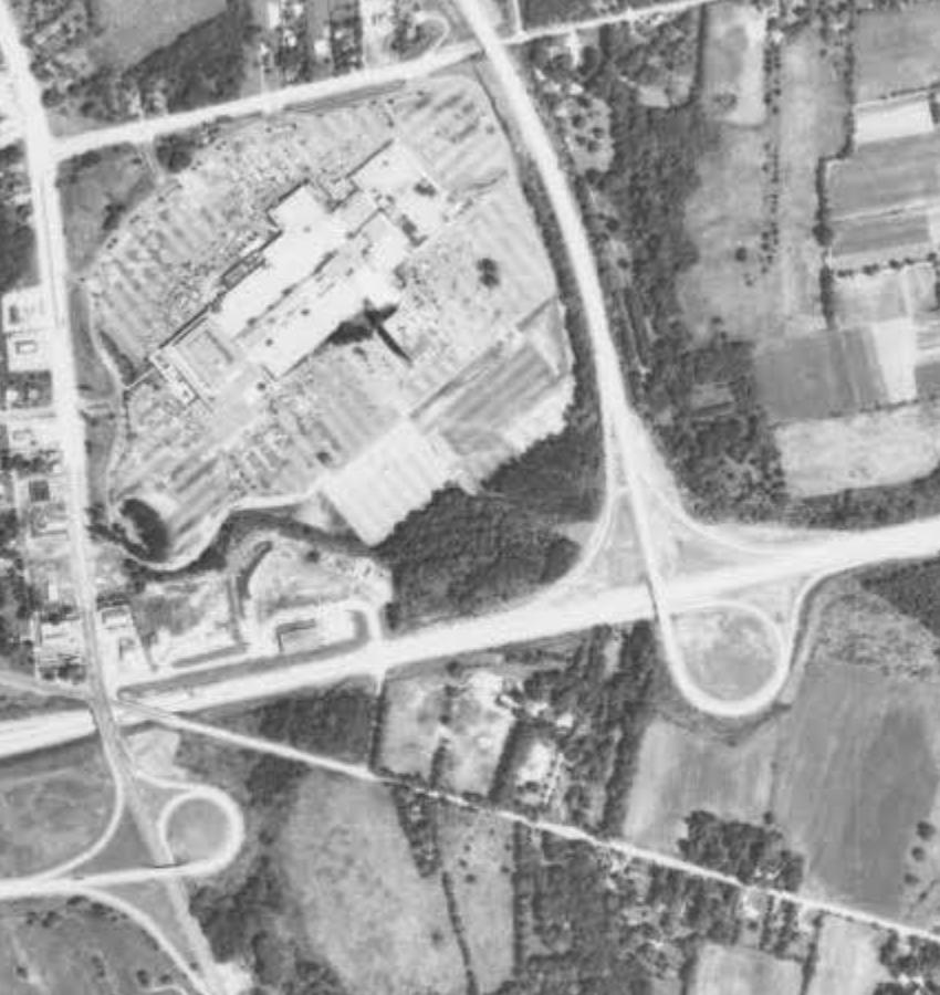
This photograph, taken on August 6, 1971, shows the Plymouth Meeting Mall taking up much of the land. Germantown Pike is the roadway seen from the left-side of the photo near the top to the bottom of the photo, the main East-West portion of the Pennsylvania Turnpike is the roadway seen from the left-side of the photo to near the middle of the right-side of the photo, the Northeast Extension of the Pennsylvania Turnpike is the highway seen from its interchange with the main East-West portion of the Turnpike in the middle of the photo near the right-side to the top middle of the photo, and Hickory Road is the roadway seen near the top of the photo.
The curvature that had existed on Hickory Road near its intersection with Germantown Pike is gone by the time of this photo; Hickory Road is now a straight road. Plymouth Road is also still a straight roadway from the left-side of the photo to the right-side of the photo near the bottom.
By 1971, heavily wooded land is now only a small portion of the overall site. The specific tree that was cut to create the “A Tree Growing In Plymouth” display was located on the land that is now the current site of the Plymouth Meeting Mall. This specific tree was 195 years old when it was cut down in 1965.
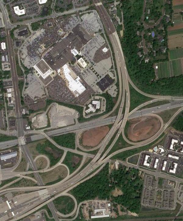
Commercial development is now almost completely covering the land bounded by Germantown Pike, Hickory Road, and the main East-West portion as well as the Northeast Extension of the Pennsylvania Turnpike. The interchanges on Germantown Pike and between the two turnpike sections were remarkably modest in size in previous years as compared to the interchanges now operational in this photograph taken in 2017.
The interchanges between Germantown Pike, the two portions of the Pennsylvania Turnpike, and the Mid-County Expressway – better known to locals as the “Blue Route” – now occupy large pieces of land in Plymouth Township. Note that Plymouth Road now curves at it approaches Germantown Pike.
(The first three aerial photos are courtesy of the United States Department of Agriculture and the Pennsylvania Geological Survey, 1942, 1958, and 1971, while the bottom map photo is courtesy of Google, 2017)
Do you have questions about local history? A street name? A building?
Your questions may be used in a future news article.
Contact Richard McDonough at freedomvalleychronicles@gmail.com.
© 2017 Richard McDonough