
In a news column on July 21st, The Freedom Valley Chronicles reported that the official map used by the Borough of Conshohocken may be incorrect.
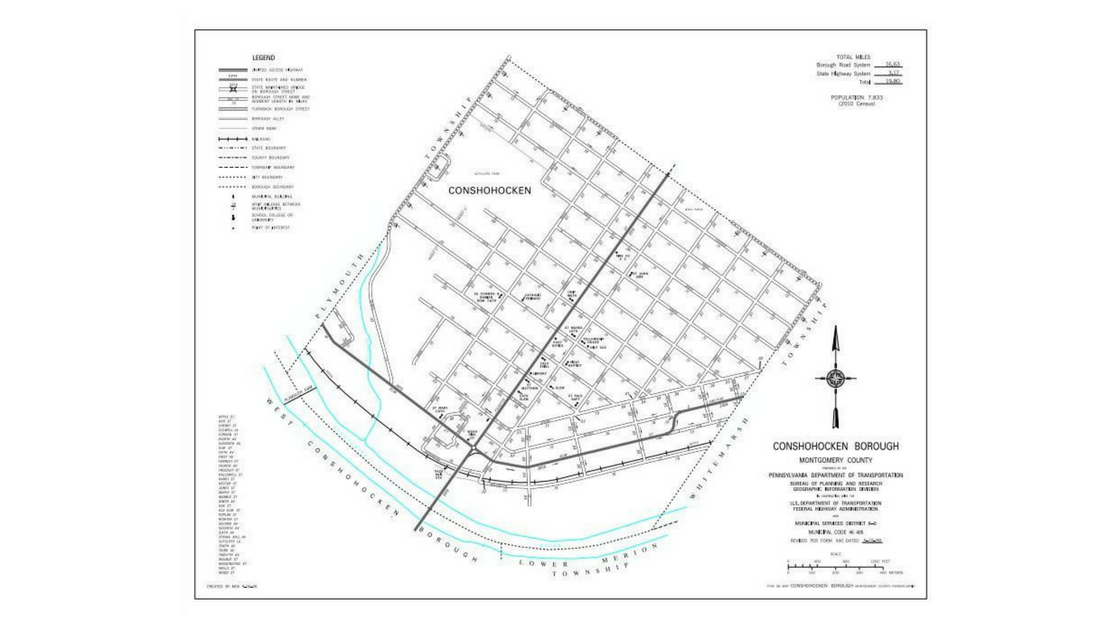
A further confirmation of that likelihood is the current Pennsylvania Department of Transportation map of the Borough of Conshohocken displayed at the top of this news column.
You can see an expandable version of the current PennDOT map of Conshohocken by clicking here.
This map was likely prepared some time during the past seven years by the Pennsylvania Department of Transportation. It shows a section of the boundary between the Borough of Conshohocken and Plymouth Township to be along Colwell Lane and the 12th Avenue alignment in the northeast section of the Borough. This conforms to the official maps of Plymouth Township and Montgomery County.
It does not match the official map utilized by the Borough of Conshohocken. The official map of the Borough includes a Notch in its northeastern section.
PennDOT shows no Notch of Conshohocken in its current map of the Borough.
The current PennDOT map of Conshohocken also shows part of the border of the Borough with Whitemarsh Township to be along Righter Street from 9th to 12th Avenues and along a matching straight line from 9th Avenue to the Schuylkill.
The current PennDOT map, however, shows that this portion of the boundary of the Borough to be the centerline of Righter Street.
This centerline border of Righter Street is not the same border as used by official maps of Montgomery County and Whitemarsh Township.
A representative of PennDOT was able to confirm that the current PennDOT map also does not match the source maps used by PennDOT to create its current map. Maps from 1932 and 1960 directly show that the border with Whitemarsh Township is along the eastern edge – not the centerline – of Righter Street from 9th to 12th Avenues and a matching straight line from 9th Avenue to the Schuylkill; a third source map – this one from 1953 – also appears to show a similar border line.
These three source maps used by PennDOT include that specific section of the Conshohocken border that matches an historical map of the Plan for the Borough of Conshohocken from 1871 as well as the map utilized by Montgomery County for real estate property records.
Based on the information from the three source maps, PennDOT is now in the process of reviewing its current map of the Borough of Conshohocken.
Beyond the review of this section of the border between Conshohocken and Whitemarsh Township, PennDOT is also reviewing an update to another section of the border between these two municipalities.
The current PennDOT map of the Borough of Conshohocken does not include the “B” Field within the boundaries of the Borough. Instead, the current PennDOT map of Conshohocken still has the “B” Field as part of Whitemarsh Township.
The “B” Field, also known as the “John Borusiewicz Memorial Field”, is a recreational facility has been owned by the Borough for decades even though the land was for much of its history officially part of Whitemarsh Township. In 1968, this parcel of land officially became part of the Borough of Conshohocken.
Updates will be provided as PennDOT completes these reviews of the current PennDOT map of the Borough of Conshohocken.
Please note that three of the maps that appeared in the first news column detailing the Notch of Conshohocken are reprinted here to illustrate the discrepancies between the current official municipal map of the Borough of Conshohocken as well as the current PennDOT map of the Borough of Conshohocken.
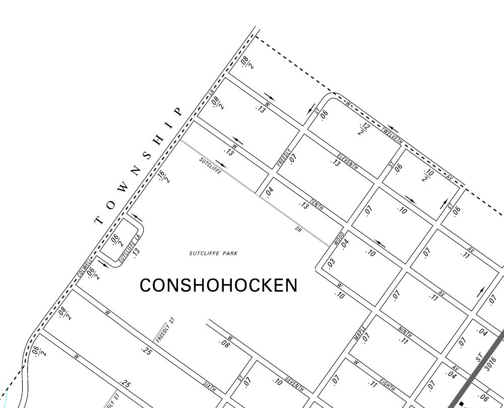
This portion of the current PennDOT map of the Borough of Conshohocken shows no Notch of Conshohocken. Instead, PennDOT shows that the border between Plymouth Township and the Borough in this area to be along Colwell Lane and the 12th Avenue alignment. Please note that this map does not show the Pleasant Valley Homes neighborhood with houses along Lenape Lane and Pleasant Valley Drive.
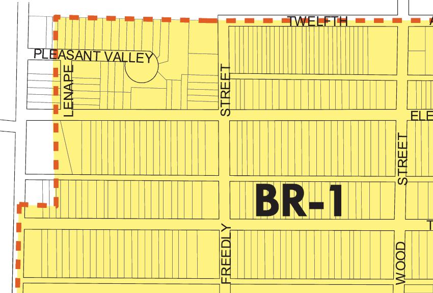
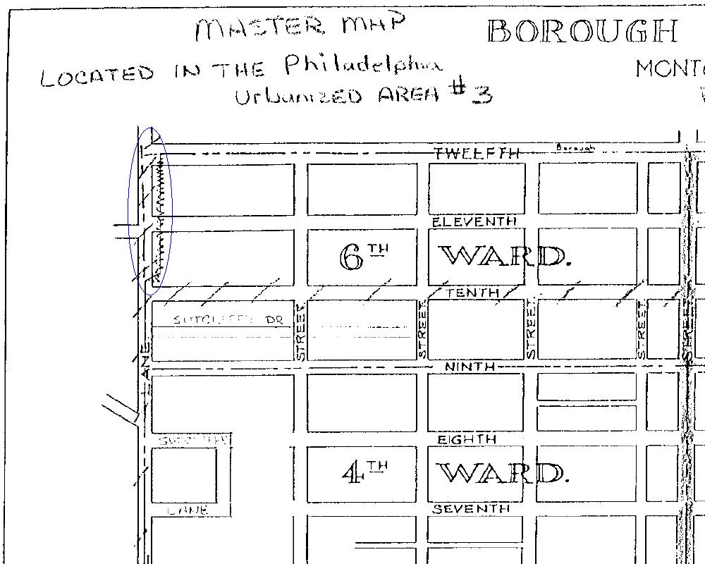
This is a detailed piece of the official map of the Borough of Conshohocken. Note the notch along Colwell Lane, from just above 10th Avenue to the 12th Avenue alignment. Certain portions of the properties in this notch area may not have zoning, at least according to the official map of the Borough of Conshohocken. Plymouth Township, Montgomery County, and PennDOT do not have the Notch of Conshohocken in their maps. Instead, all three – the Township, the County, and the Commonwealth – have the boundary between Plymouth Township and Conshohocken Borough in this section to be along Colwell Lane and the 12th Avenue alignment.
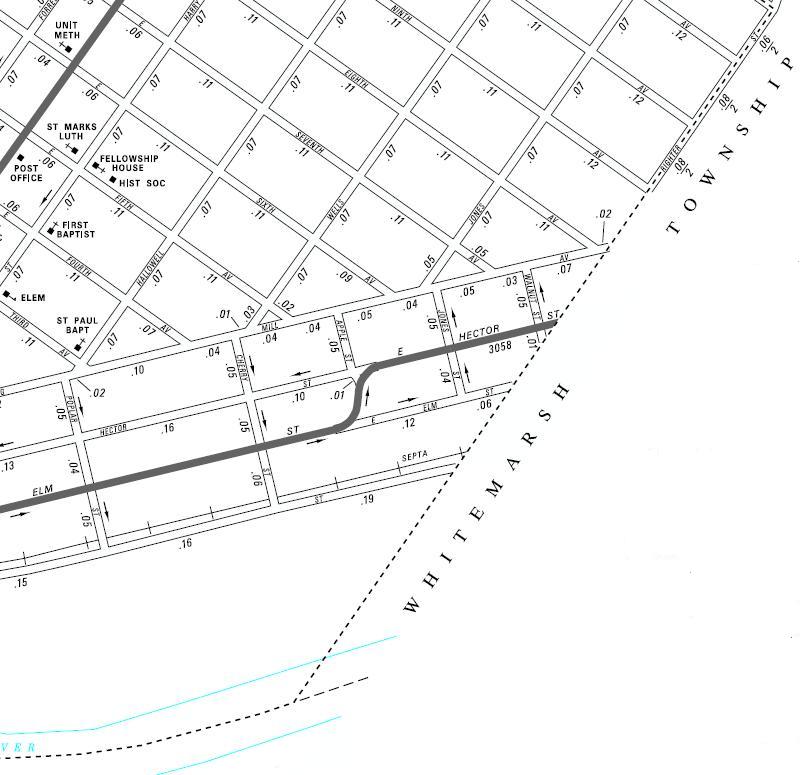
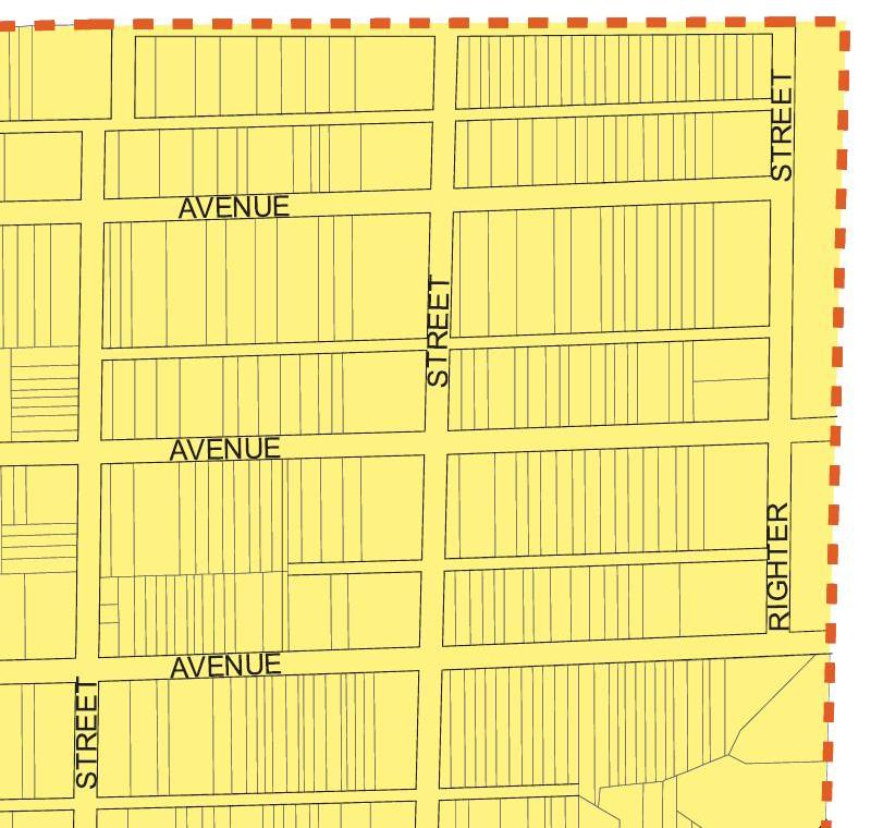
This portion of the current PennDOT map of the Borough of Conshohocken shows the border between the Borough and Whitemarsh Township to be the centerline of Righter Street from 9th to 12th Avenues and along a matching straight line from 9th Avenue to the Schuylkill. An historical map of the Plan for the Borough of Conshohocken and the map utilized by Montgomery County for real estate property records both show the boundary to be along the eastern edge of Righter Street – not the centerline – with a matching straight line to the Schuylkill. Three source maps utilized by PennDOT confirm the actual border between the two municipalities to be along the eastern edge of Righter Street between 9th and 12th Avenues with a matching straight line from 9th Avenue to the Schuylkill.

The blue line added to this map from Montgomery County shows where the County has set the boundary line between the Borough of Conshohocken and Whitemarsh Township. Montgomery County officially has the border between the two municipalities to be along the eastern edge of Righter Street between 9th and 12th Avenues and a matching straight line from 9th Avenue to the Schuylkill.
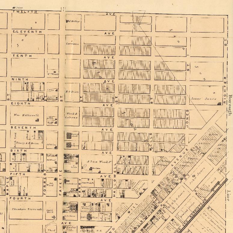
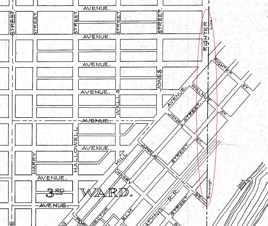
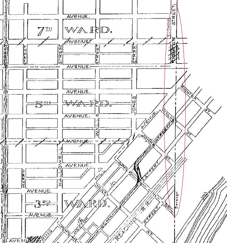
This is another detailed piece of the official map of the Borough of Conshohocken. Note the official map of the Borough shows that the boundary with Whitemarsh Township to be east of Righter Street between 9th and 12th Avenues and east of a matching straight line between 9th Avenue and the Schuylkill. This is contrary to the historical map detailing the Plan for the Borough of Conshohocken, the official maps used by Montgomery County and Whitemarsh Township, and the three source maps utilized by PennDOT.
This map of the Plan for the Borough of Conshohocken was produced in 1871. Note that eastern edge of Righter Street and a matching straight line that follows a similar alignment to the Schuylkill is the border between the Borough and Whitemarsh Township. The official map for Conshohocken today has the border east of Righter Street and the matching straight line to the Schuylkill. The current official PennDOT map of Conshohocken – which is now under review for updates – has the border between the Borough and Whitemarsh Township to be the centerline of Righter Street – rather than the edge of Righter Street – and then a matching straight line to the Schuylkill. Please note that this map from 1871 shows where the Plan for the Borough of Conshohocken anticipated roads would be built. Many of these roadways were not actually built at that time, and some of the roadways have never actually been built according to the plan.
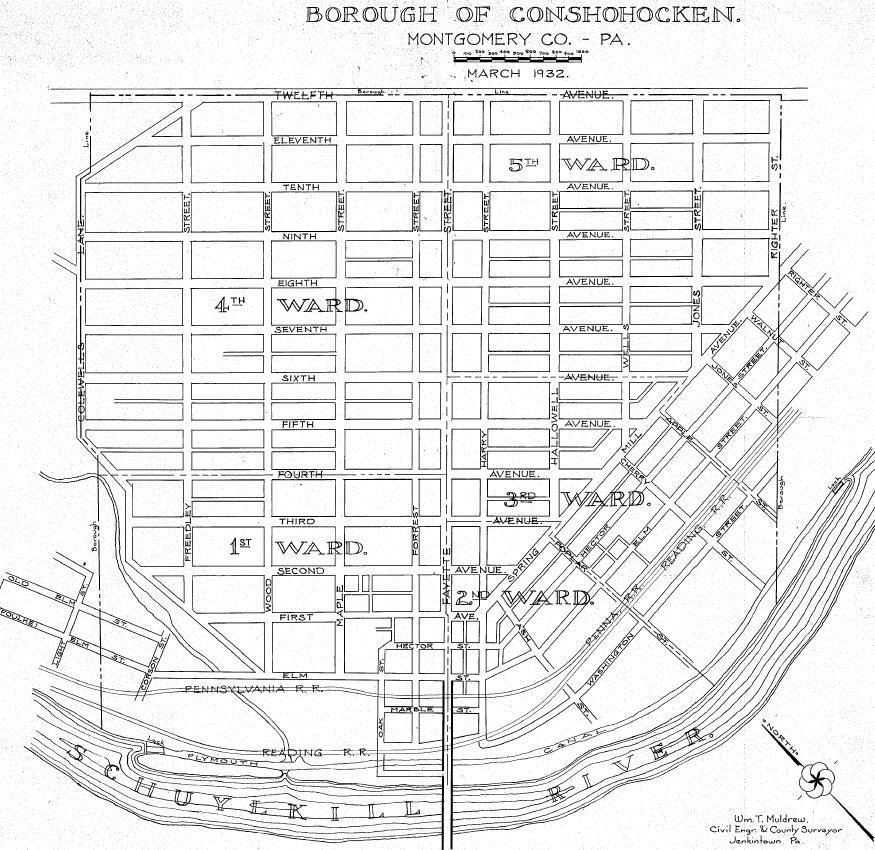
This is the 1932 map of Conshohocken utilized by PennDOT as a source map. This map may be the initial source of the Notch of Conshohocken. This map does not have the border between the Borough of Conshohocken and Plymouth Township as had been approved by the court about 6 years earlier. In 1926, the border between the two municipalities was moved about 80 west to follow Colwell Lane, from just below 5th Avenue to the 12th Avenue alignment. On the other side of the Borough, this map does show the border between the Borough and Whitemarsh Township to be along the eastern edge of Righter Street and a matching straight line to the Schuylkill.
This is a detailed piece of the 1932 map of the Borough of Conshohocken utilized as a source map by PennDOT. Note the Notch of Conshohocken in the blue circle. The diagonal street in the top left-side of this map is Whiskey Lane; this roadway no longer exists.
This is another detailed portion of the 1932 map of the Borough of Conshohocken utilized as a source map by PennDOT. The border between Conshohocken Borough and Whitemarsh Township follows the eastern edge of Righter Street from the 8th Avenue alignment to 12th Avenue and a matching straight line from the 8th Avenue alignment to the Schuylkill. This border is highlighted in the red circle. Note the wording “Borough Line” in the red circle. Also note that 8th Avenue was not built out to an intersection with Righter Street.
This is a 1953 map of the borders of the Borough of Conshohocken. This map is one of three maps that are utilized as source maps for PennDOT. Note that the northeastern borders of the Borough are both straight lines – there is no Notch of Conshohocken in this map.
This is the third of three source maps used by PennDOT to prepare the current map of the Borough of Conshohocken. In this 1960 map, the Notch of Conshohocken is removed and the northeastern borders of the Borough are moved to Colwell Lane and the 12th Avenue alignment. This map also shows that the border between Whitemarsh Township and the Borough is along the eastern edge of Righter Street from 9th to 12th Avenues and along a matching straight line from 9th Avenue to the Schuylkill.
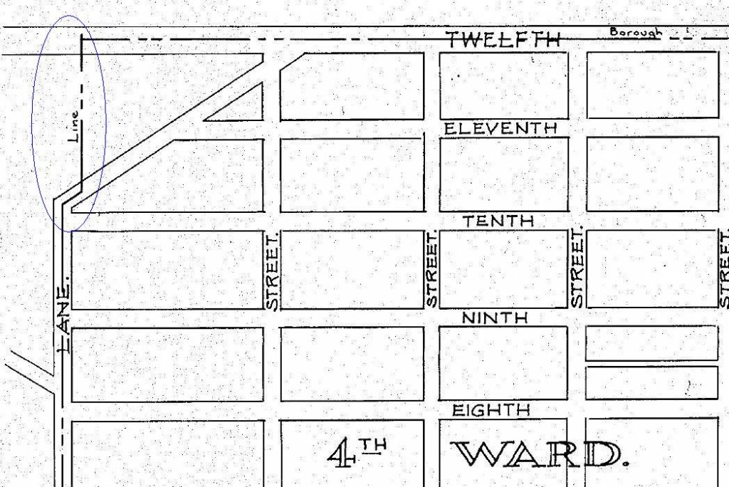
This is a detailed piece of the 1960 map of the Borough of Conshohocken utilized as a source map by PennDOT. Note the boundary for the Notch of Conshohocken along Whiskey Lane and a line about 80 feet east of Colwell Lane has been scratched out by the civil engineer. Instead, the border is now shown to be along Colwell Lane and the 12th Avenue alignment. The former Notch of Conshohocken is highlighted in the blue circle.
This is another detailed portion of the 1960 map of the Borough of Conshohocken utilized as a source map by PennDOT. Note that Righter Street is – from edge to edge – within the Borough from 9th Avenue to 12th Avenue and that the border between Conshohocken Borough and Whitemarsh Township continues along a matching straight line from 9th Avenue to the Schuylkill. This border is highlighted in the red circle. “Borough Line” is listed in the red circle.
As noted in the initial news column on the Notch of Conshohocken, the discrepancies in the border shown in the official map of the Borough of Conshohocken between the Borough and Plymouth Township may mean that portions of certain properties in the Notch of Conshohocken have no zoning and, thus, the owners of the properties in the Notch area may only have to follow zoning regulations on portions of their properties.
Also noted in the initial news column, the discrepancies in the border shown in the official map of the Borough of Conshohocken between Conshohocken and Whitemarsh Township may mean that portions of certain properties along Righter Street between 9th and 12th Avenues and the matching straight line from 9th Avenue to the Schuylkill may be in two different zoning districts at the same exact time and, thus, the owners of the properties in this area may be unable to follow either municipal zoning requirements correctly.
The Borough of Conshohocken is still reviewing this situation.
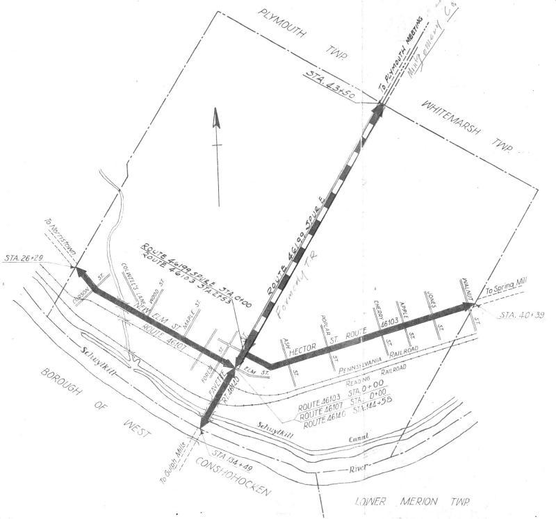
As noted above, PennDOT is in the process of reviewing its current map of the Borough of Conshohocken. Specifically, PennDOT is reviewing an update to the border between the Borough and Whitemarsh Township along Righter Street from 9th Avenue to 12th Avenue and the matching straight line from 9th Avenue to the Schuylkill. In addition, PennDOT is reviewing an update to the boundaries of the Borough of Conshohocken to add the “B” Field, also known as the “John Borusiewicz Memorial Field”, to the municipality.
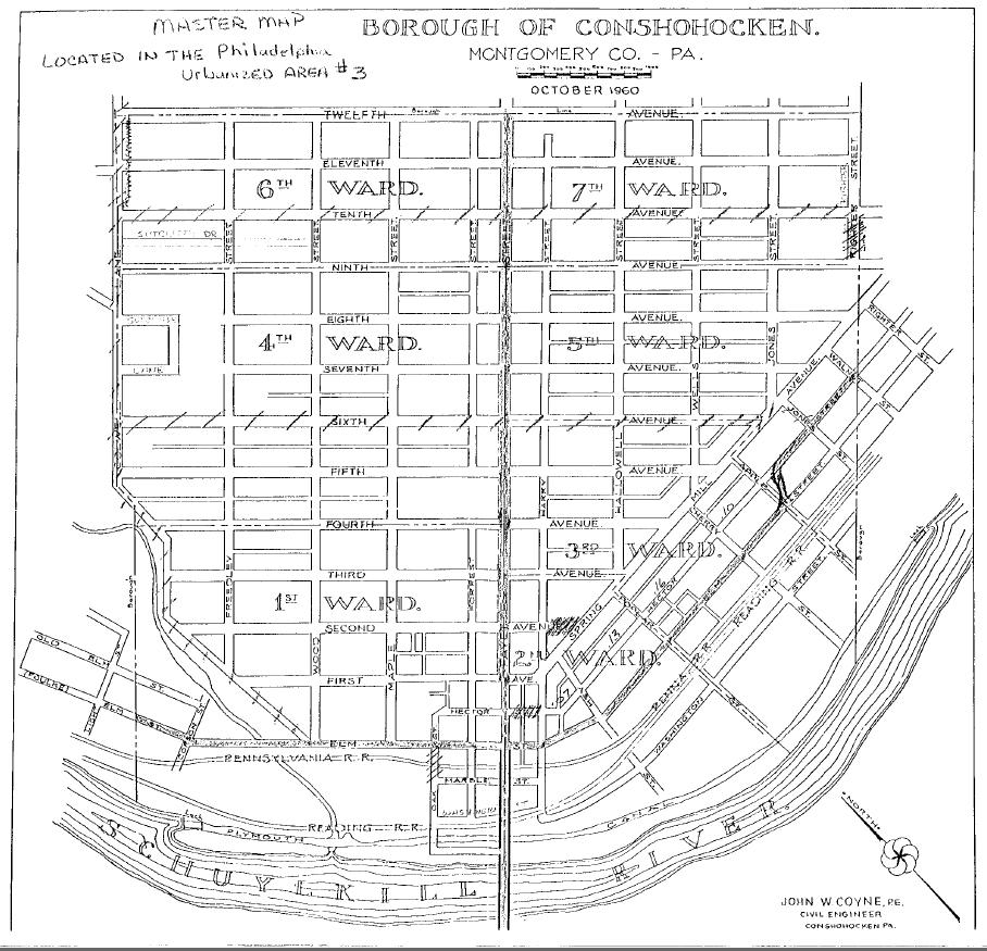
The top map is the current official Map of the Borough of Conshohocken prepared by the Pennsylvania Department of Transportation and is courtesy of Commonwealth.
The second and fourth maps are portions of the current official Map of the Borough of Conshohocken prepared by the Pennsylvania Department of Transportation and are courtesy of Commonwealth.
The third and sixth maps are portions of the official Zoning Map of the Borough of Conshohocken and are courtesy of that municipality, 2018.
The fifth map is courtesy of Montgomery County, 2018.
The seventh map is a portion of a map from 1871 and is courtesy of the Commonwealth of Pennsylvania Historical and Museum Commission.
The eighth map is the 1932 map used as a source map by the Pennsylvania Department of Transportation to create the current official Map of the Borough of Conshohocken and is courtesy of Commonwealth.
The ninth and tenth maps are portions of the 1932 map used as a source map by the Pennsylvania Department of Transportation to create the current official Map of the Borough of Conshohocken and are courtesy of Commonwealth.
The eleventh map is the 1953 map used as a source map by the Pennsylvania Department of Transportation to create the current official Map of the Borough of Conshohocken and is courtesy of Commonwealth.
The twelfth map is the 1960 map used as a source map by the Pennsylvania Department of Transportation to create the current official Map of the Borough of Conshohocken and is courtesy of Commonwealth.
The thirteenth and fourteenth maps are portions of the 1960 map used as a source map by the Pennsylvania Department of Transportation to create the current official Map of the Borough of Conshohocken and are courtesy of Commonwealth.
Do you have questions about local history? A street name? A building?
Your questions may be used in a future news column.
Contact Richard McDonough at freedomvalleychronicles@gmail.com.
© 2018 Richard McDonough